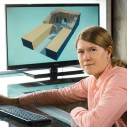
Sarah Parcak
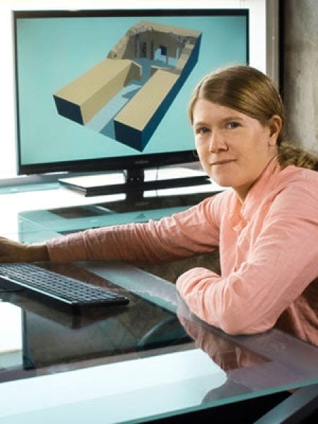
Sarah Helen Parcak (1978- ) is an archeologist and Egyptologist known for using satellite imagery to identify and survey ancient civilizations. She is a professor of anthropology and founding director of the Laboratory for Global Observation at the University of Alabama at Birmingham (UAB) in Birmingham, Jefferson County. There, Parcak collaborates with her husband, Egyptologist Greg Mumford, on the Surveys and Excavation Projects in Egypt, an ongoing collaborative project, which conducts archeological surveys on the Nile Delta, the Sinai Peninsula, and Egyptian pyramids, along with other interests.
Parcak was born in Bangor, Maine, in 1978, to John and Marjorie Parcak; she has a brother. In her youth, Parcak was inspired by Raiders of the Lost Ark, the iconic 1981 movie about the adventurous archaeologist Indiana Jones. She has also said she was inspired by her grandfather, a decorated World War II paratrooper who used aerial photographs to identify landing zones. He earned a doctorate in forestry and pioneered the use of aerial photographs to map the heights of trees.
Parcak received her bachelor’s degree in Egyptology and archaeological studies from Yale University in 2001. While an undergraduate, Parcak enrolled in a class on remote sensing (the science of gathering data about the Earth’s surface from a distance, using instruments and sensors on satellites or aircraft). Parcak taught herself the algorithms, electromagnetic spectrum analysis, and software programing necessary to pass the class and apply the skills to archeology; the subject would have a profound impact on her future work. She later earned a master’s and doctorate degree in Egyptian archaeology from the University of Cambridge, England. From 2005-06, she taught Egyptian art and history at the University of Wales, Swansea (present-day Swansea University) in Wales, United Kingdom.
Parcak married fellow archaeologist Greg Mumford in 2005; they have one child. Both she and her husband have served on the UAB faculty since 2006. In 2007, Parcak established the Laboratory for Global Observation, a computer center at UAB that uses satellite imagery to digitally map archeological sites around the world.
Parcak begins her research using satellite remote sensing technology, which uses satellites with powerful, high-definition cameras to collect high-resolution images of the Earth’s surface. Some satellites also use sensors that detect electromagnetic radiation that comes from the surface of Earth. The use of these satellites to survey potential archaeological sites allows archeologists to better understand, and even discover, the physical layout and cultures of ancient civilizations. Parcak and her team sometimes begin a project using Google Earth to get a sense of potential sites before contracting with a private company to produce images. In addition to reviewing high-resolution satellite images, Parcak and her team familiarize themselves with various existing maps and surveys. Such sources often provide information about the site that may have been overlooked during previous landscape assessments. For example, while searching for potential sites of ancient buildings along the flooding Nile River, Parcak consulted colonial-era surveys, satellite images, and 3-D topographical maps of the area. Parcak also uses near-infrared satellite imagery, which detects light that humans cannot see, to search for potential archeological sites that may be buried underground or covered by vegetation. This approach helped Parcak unearth a Viking wall near Point Rosee, Newfoundland.
Parcak has helped to advance the field of archeology by using satellite imagery. Whereas traditional methods typically focus on conducting surveys through a series of small excavation pits, Parcak’s approach dramatically increases the scale of an archeological survey. Prior to the availability of satellite imagery, archaeologists got a bird’s-eye view of potential dig sites using a variety of methods, with a few even including hot air balloons, kites, and helicopters, as well as parachutes and blimps with attached cameras. Parcak helped popularize the use of satellite imagery to potentially reveal detailed features of ancient civilizations, thereby improving our knowledge of past peoples.
Parcak gained international recognition in 2011 for mapping all of Egypt using satellite remote sensing technology. That year her team rediscovered 17 potentially unknown pyramids, more than 1,000 tombs, 3,100 settlements, and a detailed street plan of Tanis, one of the capitals of ancient Egypt, that was featured in Raiders of the Lost Ark. Additionally in 2011, Parcak created a first-of-its-kind online map that uses crowd-sourcing to document plundered tombs across the globe. The online map offers a visual reference for how ancient sites are affected by looting and urban development. Satellite mapping of historic sites reveals a 1,000-percent increase in looting since 2009, according to Parcak. Documenting these incidents helps bolster attention to this global historical crisis and promote preservation and protection initiatives for these ancient sites.
As part of her work with the Laboratory for Global Observation, Parcak and her team have found evidence of thousands of additional ancient sites across Europe, the Mediterranean basin, and the North Atlantic basin. In 2009, she was a member of a scientific team that identified the ruins of an amphitheater at the Roman harbor of Portus at the mouth of the Tiber River in central Italy for archeologists who have dedicated their careers to its recovery. She mapped the ancient Dacian capital in present-day Romania and aided in the search for prehistoric hominid fossils in Kenyan lake beds. In 2016, her satellite images revealed a potential second Viking site in Newfoundland, Canada, but a later on-site investigation found no traces of human activity. Using NASA radar, she found evidence of an ancient Egyptian suburb indicating a possible location for the lost capital of Middle Kingdom Egypt, Itjtawy. Additional discoveries in southern Jordan include an ancient ceremonial platform in Petra and a 2,500-year-old city, both built by people from the Nabatean culture.
In 2016, Parcak was awarded a $1 million dollar TED Prize to establish a crowd-sourcing project, GlobalXplorer, that would allow anyone with an internet connection to review satellite imagery to search for potential sites that may have been previously unknown and document potential looting pits or unknown tombs. Launched in 2017, the platform also serves as a nexus to promote conversations among professional archeologists and enthusiasts to discuss new sites, discoveries, and the future of the field. The effort is intended to make satellite mapping more rapid and cost effective.
Parcak has been interviewed by numerous international media outlets and has even appeared on The Late Show with Stephen Colbert, in 2016. Parcak’s research is featured in two BBC documentaries, Egypt: What Lies Beneath in 2011 and Rome’s Lost Empire in 2013. Additionally, she has collaborated with NASA and the U.S. Department of State on satellite survey projects. She is a National Geographic Society Archeology Fellow, a Fellow of the Society of Antiquaries of London, a 2013 TED Senior Fellow, and a Guggenheim Fellow (John Simon Guggenheim Memorial Foundation, 2020). Parcak published her first textbook on the field of satellite archeology, Satellite Remote Sensing for Archeology, in 2009. She followed that book with Archaeology from Space: How the Future Shapes Our Past in 2019. She has authored numerous peer-reviewed journal articles during her career.
Works by Sarah Parcak
Satellite Remote Sensing for Archeology (2009)
Archaeology from Space: How the Future Shapes Our Past (2019)