Marengo County
 Geneva Mercer
Located in the west-central region of the state, Marengo County is part of Alabama's Black Belt region. The Vine and Olive Colony, established in large part by French colonial refugees of the Haitian slave rebellion, was located in Marengo County, sculptor Geneva Mercer was born in the Jefferson community, civil-rights leader Ralph Abernathy was born in the Hopewell community, and Waldo L. Semon, the inventor of PVC (vinyl), was born in Demopolis. Marengo County is governed by an elected five-member commission and includes the incorporated communities of Linden and Demopolis.
Geneva Mercer
Located in the west-central region of the state, Marengo County is part of Alabama's Black Belt region. The Vine and Olive Colony, established in large part by French colonial refugees of the Haitian slave rebellion, was located in Marengo County, sculptor Geneva Mercer was born in the Jefferson community, civil-rights leader Ralph Abernathy was born in the Hopewell community, and Waldo L. Semon, the inventor of PVC (vinyl), was born in Demopolis. Marengo County is governed by an elected five-member commission and includes the incorporated communities of Linden and Demopolis.
- Founding Date: February 6, 1818
- Area: 982 square miles
- Population: 19,323 (2020 Census estimate)
- Major Waterways: Tombigbee River, Black Warrior River
- Major Highways: U.S. 43, U.S. 80
- County Seat: Linden
- Largest City: Demopolis
History
 Old Marengo County Courthouse
Marengo County was created by the Alabama Territorial Legislature on February 6, 1818, preceding Alabama's statehood by almost two years. The land was acquired from the Choctaw Indians under the 1816 Treaty of Fort St. Stephens. In 1817, a group of French immigrants who had been given refuge in the United States after a slave rebellion in Haiti, were given land to establish a colony dedicated to growing wine grapes and olives. The settlers were granted four townships of land by an act of Congress on March 3, 1817. The county's name was suggested by Judge Abner Lipscomb in keeping with the mythology that at least some of the settlers had served with French Gen. Napoleon Bonaparte in his victory at Marengo, Italy, over Austrian forces on June 14, 1800. The settlers of the Vine and Olive Colony, as it came to be known, founded several towns, including Demopolis. When the area was officially opened to general settlement in 1818, pioneers came mostly from Virginia, the Carolinas, and Georgia. Later settlers traveled from Kentucky and Tennessee via the Federal Road. The first towns in the area that would become Marengo County were Linden, Demopolis, Myrtlewood, and Sweet Water.
Old Marengo County Courthouse
Marengo County was created by the Alabama Territorial Legislature on February 6, 1818, preceding Alabama's statehood by almost two years. The land was acquired from the Choctaw Indians under the 1816 Treaty of Fort St. Stephens. In 1817, a group of French immigrants who had been given refuge in the United States after a slave rebellion in Haiti, were given land to establish a colony dedicated to growing wine grapes and olives. The settlers were granted four townships of land by an act of Congress on March 3, 1817. The county's name was suggested by Judge Abner Lipscomb in keeping with the mythology that at least some of the settlers had served with French Gen. Napoleon Bonaparte in his victory at Marengo, Italy, over Austrian forces on June 14, 1800. The settlers of the Vine and Olive Colony, as it came to be known, founded several towns, including Demopolis. When the area was officially opened to general settlement in 1818, pioneers came mostly from Virginia, the Carolinas, and Georgia. Later settlers traveled from Kentucky and Tennessee via the Federal Road. The first towns in the area that would become Marengo County were Linden, Demopolis, Myrtlewood, and Sweet Water.
 Thomaston Colored Institute
The county seat was originally known as the Town of Marengo. Its name was changed in 1823 to Linden, a shortened version of Hohenlinden, the scene of another French victory in Bavaria in 1800. In 1820, the county constructed a two-room log courthouse in the Old Town part of Linden. This courthouse was replaced in 1825 with a larger, two-story log courthouse that burned in 1848. In the 1850s, a two-story Federal-style courthouse was constructed and remains the oldest Greek Revival courthouse in Alabama. It was used continuously until 1902, except for a brief period during Reconstruction, when the county seat was located in Demopolis. In 1903, a new Gothic-style courthouse was constructed; it burned in 1965 and was replaced in 1968 by the current courthouse.
Thomaston Colored Institute
The county seat was originally known as the Town of Marengo. Its name was changed in 1823 to Linden, a shortened version of Hohenlinden, the scene of another French victory in Bavaria in 1800. In 1820, the county constructed a two-room log courthouse in the Old Town part of Linden. This courthouse was replaced in 1825 with a larger, two-story log courthouse that burned in 1848. In the 1850s, a two-story Federal-style courthouse was constructed and remains the oldest Greek Revival courthouse in Alabama. It was used continuously until 1902, except for a brief period during Reconstruction, when the county seat was located in Demopolis. In 1903, a new Gothic-style courthouse was constructed; it burned in 1965 and was replaced in 1968 by the current courthouse.
Major Cities and Demographics
 Bluff Hall
According to 2020 Census estimates, the population of Marengo County was 19,323. Of that total, 51.6 percent of respondents identified themselves as African American, 46.5 percent as white, 3.0 percent as Hispanic, 1.1 percent as two or more races, 0.4 percent as Asian, 0.3 percent as Native American, and 0.2 percent as Pacific Islander. The largest city is Demopolis, with an estimated population of 7,162. County seat Linden had an estimated population of 1,930. Other significant population centers include Faunsdale, Thomaston, Providence, and Sweet Water. The median household income was $33,029, compared with $52,035 for the state as a whole, and the per capita income was $27,975, compared with the $28,934 average for the state.
Bluff Hall
According to 2020 Census estimates, the population of Marengo County was 19,323. Of that total, 51.6 percent of respondents identified themselves as African American, 46.5 percent as white, 3.0 percent as Hispanic, 1.1 percent as two or more races, 0.4 percent as Asian, 0.3 percent as Native American, and 0.2 percent as Pacific Islander. The largest city is Demopolis, with an estimated population of 7,162. County seat Linden had an estimated population of 1,930. Other significant population centers include Faunsdale, Thomaston, Providence, and Sweet Water. The median household income was $33,029, compared with $52,035 for the state as a whole, and the per capita income was $27,975, compared with the $28,934 average for the state.
Economy
 Marengo County Timber
Like most of Alabama's counties, farming was the prevailing occupation in Marengo County until the middle of the twentieth century. After the failure of the Vine and Olive Colony, the colonists and other settlers turned to cultivating cotton, which was the most prevalent cash crop until the 1930s. During the Great Depression, farmers diversified into corn and livestock and turned cotton fields into pasture for beef and dairy cows. In the 1960s, farmers began raising soybeans and constructing ponds for catfish farming. Marengo County's economy was mainly agricultural until the mid-twentieth century, but its many acres of forest along the Tombigbee River also provided employment in the timber industry.
Marengo County Timber
Like most of Alabama's counties, farming was the prevailing occupation in Marengo County until the middle of the twentieth century. After the failure of the Vine and Olive Colony, the colonists and other settlers turned to cultivating cotton, which was the most prevalent cash crop until the 1930s. During the Great Depression, farmers diversified into corn and livestock and turned cotton fields into pasture for beef and dairy cows. In the 1960s, farmers began raising soybeans and constructing ponds for catfish farming. Marengo County's economy was mainly agricultural until the mid-twentieth century, but its many acres of forest along the Tombigbee River also provided employment in the timber industry.
Employment
According to 2020 Census estimates, the workforce in Marengo County was divided among the following industrial categories:
- Educational services, and health care and social assistance (27.1 percent)
- Manufacturing (17.7 percent)
- Retail trade (7.9 percent)
- Public administration (7.5 percent)
- Construction (6.9 percent)
- Transportation and warehousing, and utilities (6.9 percent)
- Professional, scientific, management, and administrative and waste management services (5.2 percent)
- Other services, except public administration (5.0 percent)
- Arts, entertainment, recreation, and accommodation and food services (4.9 percent)
- Agriculture, forestry, fishing and hunting, and extractive (4.5 percent)
- Finance and insurance, and real estate, rental, and leasing (3.6 percent)
- Information (1.8 percent)
- Wholesale trade (1.0 percent)
Education
The Marengo County School System oversees three primary and secondary schools. In addition, the Demopolis City Schools oversees seven primary and secondary schools and the Linden City Schools oversees five primary and secondary schools.
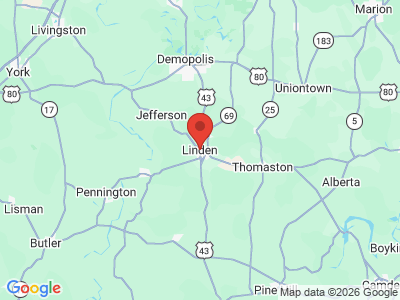
Geography
 Marengo County Map
Comprising approximately 982 square miles, Marengo County lies in the west-central part of the state. The county lies within the East Gulf Coastal Plain physiographic section of the Atlantic Plain region. It is bordered to the north by Hale and Greene Counties, to the northeast by Perry, Dallas, and Wilcox Counties, to the south by Clarke County, and to the west by Choctaw and Sumter Counties. A strip of dark black prairie soil known as the Black Belt runs through the northern part of the county, and the southern part of the county consists of sandy and clay soils.
Marengo County Map
Comprising approximately 982 square miles, Marengo County lies in the west-central part of the state. The county lies within the East Gulf Coastal Plain physiographic section of the Atlantic Plain region. It is bordered to the north by Hale and Greene Counties, to the northeast by Perry, Dallas, and Wilcox Counties, to the south by Clarke County, and to the west by Choctaw and Sumter Counties. A strip of dark black prairie soil known as the Black Belt runs through the northern part of the county, and the southern part of the county consists of sandy and clay soils.
The Black Warrior River merges with the smaller Tombigbee River in Demopolis in the northernmost part of the county. The Tombigbee River forms the western border of the county. Both rivers are considered amongst the most critical watersheds in the nation, with more than 125 species of fish, 10 of which are considered at risk. Numerous tributaries offer scenic views and recreational opportunities.
U.S. Highways 43 and 80 are the county's major transportation routes. U.S. Highway 43 runs north-south through the middle of the county, and U.S. 80 runs east-west along the northern part of the county. The Demopolis Municipal Airport and Freddie Jones Field in Linden are Marengo County's two public airports.
Events and Places of Interest
 Alabama Rural Heritage Foundation and Center
Marengo County offers many opportunities for recreation. For example, the scenic Black Warrior and Tombigbee Lakes system, which encompasses Bankhead Lake, Holt Lake, Oliver Lake, Warrior Lake, Demopolis Lake, and Coffeeville Lake, offers numerous recreational activities such as hunting, fishing, boating, hiking, and camping. The 520-acre Chickasaw State Park features campsites, a wading pool, and hiking trails as well as large pavilions and picnic sites. The Alabama Rural Heritage Foundation and Center is located in Thomaston, at the former Marengo County High School. Completed in 1909, the building is the oldest standing county high school in the state. Begun in 1986 and incorporated as a non-profit foundation in 1990, the center displays and sells traditional folk art and crafts from across the state, serving as a community hub and new source of income for the area.
Alabama Rural Heritage Foundation and Center
Marengo County offers many opportunities for recreation. For example, the scenic Black Warrior and Tombigbee Lakes system, which encompasses Bankhead Lake, Holt Lake, Oliver Lake, Warrior Lake, Demopolis Lake, and Coffeeville Lake, offers numerous recreational activities such as hunting, fishing, boating, hiking, and camping. The 520-acre Chickasaw State Park features campsites, a wading pool, and hiking trails as well as large pavilions and picnic sites. The Alabama Rural Heritage Foundation and Center is located in Thomaston, at the former Marengo County High School. Completed in 1909, the building is the oldest standing county high school in the state. Begun in 1986 and incorporated as a non-profit foundation in 1990, the center displays and sells traditional folk art and crafts from across the state, serving as a community hub and new source of income for the area.
 Gaineswood
The Marengo County History and Archive Museum, which displays artifacts and other items related to the county's history and culture, is located in the historic Rosenbush building, a former furniture store. Historic downtown Demopolis is home to several buildings listed on the National Register of Historic Places. Gaineswood mansion, a nationally renowned example of Greek Revival antebellum architecture, was built between 1843 and 1861 under the direction of Gen. Nathan Whitfield. It was opened to the public in 1975 and stands as a reminder of the plantation era, when the Black Belt was the most influential area of Alabama. Other historic homes include Bluff Hall, built in 1832 and now a museum of local history, and Lyon Hall, built around 1850 and another example of Greek Revival architecture. Laird Cottage houses the Geneva Mercer Museum, which celebrates the life and work of the local sculptor. Demopolis is also home to Christmas on the River, which is noted for its floating light displays that adorn the Tombigbee River annually on the first weekend of December. The festival also features candlelight tours of the city's many historic homes as well as a barbecue cook-off.
Gaineswood
The Marengo County History and Archive Museum, which displays artifacts and other items related to the county's history and culture, is located in the historic Rosenbush building, a former furniture store. Historic downtown Demopolis is home to several buildings listed on the National Register of Historic Places. Gaineswood mansion, a nationally renowned example of Greek Revival antebellum architecture, was built between 1843 and 1861 under the direction of Gen. Nathan Whitfield. It was opened to the public in 1975 and stands as a reminder of the plantation era, when the Black Belt was the most influential area of Alabama. Other historic homes include Bluff Hall, built in 1832 and now a museum of local history, and Lyon Hall, built around 1850 and another example of Greek Revival architecture. Laird Cottage houses the Geneva Mercer Museum, which celebrates the life and work of the local sculptor. Demopolis is also home to Christmas on the River, which is noted for its floating light displays that adorn the Tombigbee River annually on the first weekend of December. The festival also features candlelight tours of the city's many historic homes as well as a barbecue cook-off.
Additional Resources
- The Heritage of Marengo County, Alabama. Clanton, Ala.: Heritage Publishing Consultants, 2000.
- Meador, Daniel John. Rembert Hills and Myrtlewood: From Cotton Kingdom to Great Depression. Charlottesville, Va.: Daniel J. Meador, 2000.
External Links
- Marengo County
- Marengo County School District
- City of Demopolis
- Town of Linden
- Town of Sweet Water
- Town of Thomaston
- Demopolis Public Library
- Demopolis Area Chamber of Commerce
- Marengo-Union Chamber of Commerce
- Marengo County Historical Society
- National Register of Historic Places: Marengo County
- Bluff Hall
- Laird Cottage and Geneva Mercer Museum
- Chickasaw State Park