East Gulf Coastal Plain Physiographic Section
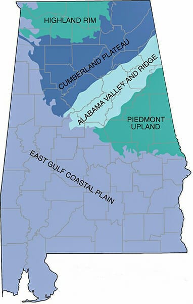 Location of East Gulf Coastal Plain
Alabama’s East Coast Gulf Coastal Plain section lies within the Coastal Plain province of the Atlantic Plain region. Hereafter called the Coastal Plain, it is one of Alabama’s five physiographic sections, each of which is recognized by its pattern of relief features and landforms that differ significantly from those of adjacent sections. The Coastal Plain section is the southernmost part of the Coastal Plain province of the Atlantic Plain Region and it is Alabama’s largest physiographic section, occupying about 60 percent of the state. The section encompasses entirely or in part 40 of Alabama’s 67 counties. Its northern boundary, often known as the fall line, forms a large, sweeping curve from Phenix City, in Russell County, to the Alabama-Mississippi border west of Florence, in Lauderdale County. The Coastal Plain continues northwest into Mississippi, where it occupies most of the state, and northeast into Georgia. Although called a plain, the Coastal Plain includes a wide variety of landscapes. It is flat and relatively featureless in some areas, but elsewhere it consists of rounded and eroded hills, topographic features known as cuestas and flatwoods, and the floodplains of the Alabama, Tombigbee, and Black Warrior rivers.
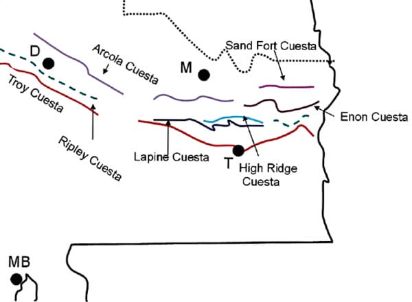 East Gulf Coastal Plain Major Cuestas
The Coastal Plain developed on geologically young Mesozoic to Recent (from about 140 million years ago to the present) sedimentary rocks and sediment. The geologic units, composed mainly of sediments, are described variously as gravels, sands, silts, and clays. The rocks are mainly composed of chalk, sandstone, limestone, and claystone. The beds slope gently southward at about 40 feet per mile and are progressively younger from the fall line to the coast. Locally, higher elevations are underlain by more resistant material (in some areas it is sediment, in others sedimentary rock), and the lowlands are underlain by softer material. The type of resistant material varies from one physiographic district to another.
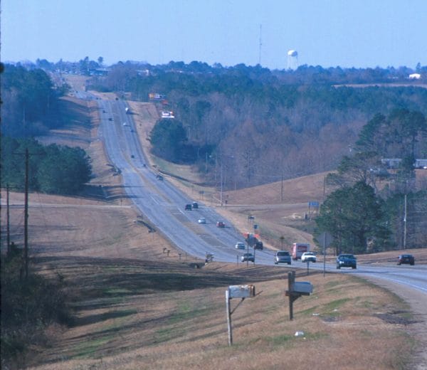 Pike County Cuesta
In this distinctive landscape, numerous cuestas trend roughly northwest-southeast, and each north-facing slope is steeper than the gentler south-facing slope, an indication of the dip of the underlying beds. The valleys tend to appear as distorted V shapes in profile, with a gentler northern and a steeper southern slope. The difference in elevation, or relief, between the top of cuesta and the floor of the flatwoods can reach 300 feet. Major cuestas occur in the Black Prairie, Chunnenuggee Hills, and Southern Red Hills districts.
Districts
Eight districts occur in this section: Fall Line Hills, Black Prairie, Chunnenuggee Hills, Southern Red Hills, Lime Hills, Southern Pine Hills, Dougherty Plain, and Coastal Lowlands.
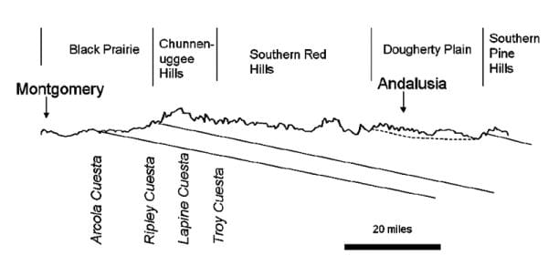 East Gulf Coastal Plain Cross-section
The most northerly district of the Coastal Plain is the Fall Line Hills. Its rounded hills are cut by valleys with local relief of between 200 and 250 feet and are underlain by sands and gravels, clays, beds of fossil oyster shells, and occasionally sandstone. For most of its southern boundary, the Fall Line Hills contacts the Black Prairie at elevations that range from 200 to 250 feet above sea level. East of Hurtsboro, in Russell County, however, it contacts the Chunnenuggee Hills along the Sand Fort Cuesta, whose north-facing slope rises 130 feet.
The Black Prairie district is a unique landscape in Alabama. Bordered by the Fall Line Hills to the north and the Chunnenuggee Hills to the south, this belt stretches from Gainesville, in Sumter County, through historic towns such as Demopolis, Selma, and Montgomery, and ends at the intersection of Bullock, Macon, and Russell Counties, southwest of Tuskegee. The Black Prairie is about 18 miles at its widest point and about 145 miles long. Elevations range from about 250 feet along the Fall Line Hills to more than 400 feet in the south. The Black Prairie owes its character to the underlying chalk rocks, which are soluble (easily dissolved) by surface and groundwater.
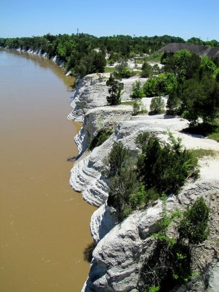 Demopolis Chalk
The land overlying the Mooreville Chalk is low and rolling and is characterized by thick black topsoil and vegetation typical of a prairie ecosystem. At the northern border of the Mooreville Chalk, a resistant limestone forms the Arcola cuesta where the formation meets the Demopolis Chalk. In contrast, the land overlying the Demopolis Chalk, which is more resistant to erosion, tends to have a very thin soil horizon, and sparser vegetation. The Black Prairie’s boundary with the Chunnenuggee Hills district changes from east to west. In the east in Russell County, the boundary is the Enon cuesta, which is about 130 feet in height. In the central and western areas, the boundary is the Ripley cuesta, which is between 50 feet and 125 feet high.
The Chunnenuggee Hills district, which includes the Sand Fork, Enon, Lapine, High Ridge and Ripley cuestas, formed on sands and sandstones. Along the 175-foot-high Lapine cuesta, in the central region, the hills reach elevations of more than 570 feet above sea level. In the western regions, the Chunnenuggee Hills are very narrow and are bounded by the Ripley and Troy cuestas.
The Southern Red Hills district formed on sands, limestone, marls, clay, and silt, and elevations in these hills commonly reach more than 400 feet above sea level with local relief of as much as 200 feet. The northern boundary is the Troy cuesta (between 80 and 140 feet high), which developed on sand. The southern boundary occurs where the hills give way to the flatlands of the Dougherty Plain district in the east and central areas.
The Chunnenuggee and Southern Red Hills districts become narrower to the west. Collectively, they are about 60 miles along the Alabama-Georgia border and about 20 miles at the Alabama-Mississippi border.
The Lime Hills district occurs in the southwestern part of the Coastal Plain. Although generally lower than the surrounding districts, the hills are rugged, with very narrow and steep ridges and valleys (with relief from 150 feet to 170 feet) cut into sands, silts, and clays. The Lime Hills grade into the Dougherty Plain.
The Dougherty Plain district is a flatland slightly tilted to the south and underlain by residual material from the weathering of limestone, sand, and clay. It runs from just east of Monroeville, Conecuh County, east-southeast for about 100 miles to the Alabama-Florida-Georgia border. It widens to about 25 miles in Covington and Houston Counties. Elevations are between 300 and 350 feet along its boundary with the Southern Pine Hills district and as low as 160 feet in Houston County. The plain includes much of the Wiregrass region of Alabama. A characteristic of this area is the absence of streams, because the rocks are so soluble that most water flows beneath the surface.
The Southern Pine Hills district occurs in the extreme southern portions of the state, from western Covington County to the Mississippi border. The boundary between these hills and the Dougherty Plain in the east and the Lime Hills to the north and west is marked by a noticeable increase in elevation. The Southern Pine Hills district is generally around 300 feet in elevation, but some hills reach elevations of slightly more than 500 feet above sea level near Grove Hill, in Clarke County. At the coast, elevations decrease to less than 50 feet.
The Coastal Lowlands district developed primarily on sand and mud. The landforms are highly variable, being continually modified by wind, tides, currents, and waves.
River Systems
Five main rivers flow through the Coastal Plain: the Chattahoochee, Choctahatchee, Conecuh, Alabama, and Tombigbee-Black Warrior. With the exception of the Tombigbee River, the rivers generally flow south-southwest across the physiographic districts and all cut though the prominent cuestas and hills. In many places, the tributaries flow at right angles to the main streams in the valleys and flatwoods. This pattern can be explained by the varying erosive forces of the rivers. The streams with higher discharge had sufficient erosive power to cut through both resistant and soft materials and formed major southwesterly trending rivers. Smaller tributaries tend to erode only the softer materials, thus forming the cuesta-flatwoods landscape.
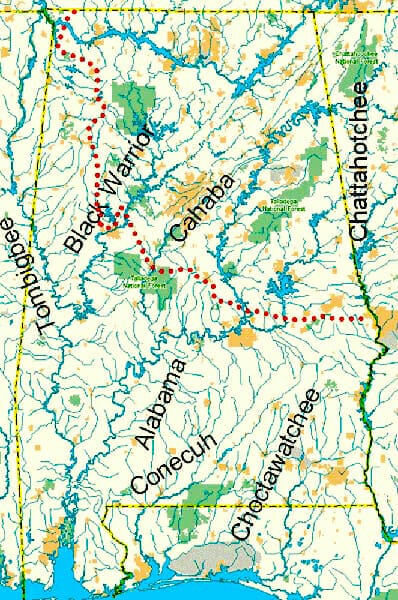 East Gulf Coastal Plain River Systems
The Alabama River, the largest in the state, forms at Wetumpka, in Elmore County, at the joining of the Coosa and the Tallapoosa Rivers. From there, it flows southwest and is joined by the Cahaba near Selma, in Dallas County, and the Tombigbee near Mount Vernon, in Mobile County, where it becomes the Mobile River before emptying into Mobile Bay. The Alabama has a well-defined alluvial plain composed of material deposited by the river itself. The plain reaches up to six miles wide in Clarke County, and the river meanders over it for its entire course. Smaller alluvial plains occur along the Cahaba, Black Warrior, Tombigbee, and Chattahoochee rivers. To aid river navigation, the Tennessee Valley Authority (TVA) constructed three locks on the Alabama south of Montgomery from 1969 to 1972. In addition, the TVA built the Millers Ferry Dam and Robert F. Henry Dam and related hydroelectric plants. The Alabama, which is the fourth-largest river system in the United States based on discharge, brings five million tons per year of suspended sediment and 62,500 cubic feet-per-second of water into Mobile Bay. The Mobile-Tensaw Delta occurs where the Alabama flows into Mobile Bay. It is shaped like a distorted triangle and begins just south of I-65 near Creola, in Mobile County, widening to about seven miles in the south at the I-10 Bridge. The location of the southern terminus of the delta depends on the balance between sediment being transported by the river and deposited in the delta and erosion of that sediment by wave and tidal action and human activity.
 Mobile Bay Gas Platforms
The Tombigbee and Black Warrior rivers join at Demopolis, in Marengo County, and are part of the $2 billion Tennessee-Tombigbee Waterway. Approved by Congress in 1946, the aim of the waterway was to shorten the distance that freight had to be carried to the Gulf Coast. The TVA excavated a 27-mile-long, 12-foot-deep navigation canal to join the headwaters of the Tombigbee at Pickwick Lake on the Tennessee River and constructed 205 miles of canals, five dams, and 10 locks on the Tombigbee River. The Heflin and Bevill lock-and-dam systems are located in Alabama, whereas the rest are in Mississippi.
Natural Resources
Oil and gas are significant economic resources in the Coastal Plain. Alabama’s output in 2003 placed the state 15th in the nation in petroleum production and 11th in the nation in natural gas production. Alabama’s oil and gas fields occur in two areas in the Coastal Plain. Oil and gas are extracted from the Smackover Formation, a rock unit that dates to Late Jurassic period. Oil is found at depths of more than 10,000 feet beneath the southwestern counties, and gas is extracted at depths of greater than 2,000 feet in the southern Mobile Bay field.
Further Reading
- Adams, G. I., et al. Geology of Alabama. Geological Survey of Alabama Special Report 14. Tuscaloosa, Ala.: Geological Survey of Alabama, 1926.
- Jones D. E. Geology of the Coastal Plain of Alabama. Guidebook of the 80th Meeting of the Geological Society of America, New Orleans, 1967.
- Lacefield, J. Lost Worlds in Alabama Rocks. Tuscaloosa: Alabama Museum of Natural History, 2018.

