Ghost Creek Falls and Natural Bridge
 Natural Bridge in Marshall County
The Natural Bridge and Ghost Creek Falls are located in Marshall County near Grant, in the community of Honeycomb. Set amid the hills of the Cumberland Plateau physiographic section, the 25-foot-long natural bridge is the remnant of a collapsed cave. Ghost Creek Falls runs a few yards away alongside the bridge. The creek is so named because it meanders in and out of the rocky cliff, appearing and disappearing as it runs down the hill. There are also two smaller waterfalls near the home the owners built on the property that emerge from other underground areas along the cliff. In 2007, the site was named one of the Seven Wonders of Marshall County by area residents.
Natural Bridge in Marshall County
The Natural Bridge and Ghost Creek Falls are located in Marshall County near Grant, in the community of Honeycomb. Set amid the hills of the Cumberland Plateau physiographic section, the 25-foot-long natural bridge is the remnant of a collapsed cave. Ghost Creek Falls runs a few yards away alongside the bridge. The creek is so named because it meanders in and out of the rocky cliff, appearing and disappearing as it runs down the hill. There are also two smaller waterfalls near the home the owners built on the property that emerge from other underground areas along the cliff. In 2007, the site was named one of the Seven Wonders of Marshall County by area residents.
 Meekins Home
The natural bridge is located on private property, but the owner, Carol Meekins, permits visitors owing to the site's uniqueness. The property, which encompasses 40 acres, is located in a clearing at the bottom of a limestone cliff riddled with small underground waterways and springs; the type of geologic structure is known as karst. Over millions of years, the mildly acidic water has produced fissures, sinkholes, underground streams, and caverns in the region. The natural bridge is the remnant of such a cavern. Over time, the walls and roof of the opening were gradually worn away, and portions collapsed, leaving the natural arch as all that remains of the cavern's roof. The bottom layer of the natural arch continues to be very fragile, and sections of rock still occasionally fall out of the layers supporting the natural bridge. An attempt by Vulcan Materials several years ago to open a quarry on adjoining property was thwarted by residents concerned about its effects on the natural bridge.
Meekins Home
The natural bridge is located on private property, but the owner, Carol Meekins, permits visitors owing to the site's uniqueness. The property, which encompasses 40 acres, is located in a clearing at the bottom of a limestone cliff riddled with small underground waterways and springs; the type of geologic structure is known as karst. Over millions of years, the mildly acidic water has produced fissures, sinkholes, underground streams, and caverns in the region. The natural bridge is the remnant of such a cavern. Over time, the walls and roof of the opening were gradually worn away, and portions collapsed, leaving the natural arch as all that remains of the cavern's roof. The bottom layer of the natural arch continues to be very fragile, and sections of rock still occasionally fall out of the layers supporting the natural bridge. An attempt by Vulcan Materials several years ago to open a quarry on adjoining property was thwarted by residents concerned about its effects on the natural bridge.
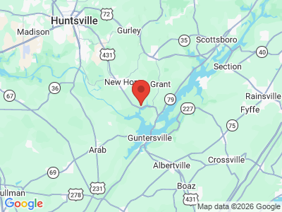
The owners were collectors of azaleas and rhododendrons and they planted more than 1,000 native and cultivated azaleas and rhododendrons in the vicinity of the bridge. Jim Meekins died in 2015, but Carol continues to maintain the gardens. Visitors are encouraged to stop and see the natural bridge and the surrounding area. The site can be accessed by turning northeast onto Cottonville Road at mile marker 308 on U. S. Hwy. 431, near Guntersville, and traveling for half a mile as the road curves sharply right. The arch is located 100 feet straight back from the entrance to the property.
The property averages 25 visitors every week, with slightly more during spring flower season. There is a campground, beach, and public boat launch nearby for visitors to the area.