Cambrian Period
 Early Cambrian Earth
The Cambrian Period (~541 to 485 million years ago) was a pivotal time in the history of life on Earth. During the Cambrian, the first documented animals with macroscopic skeletons appeared, as well as the first documented continent-wide marine flooding of what is now North America. In Alabama, this ancient marine environment left behind deposits that are economically and scientifically important, including the limestones and dolostones of the Valley and Ridge and marbles of the Piedmont provinces. In the fossil record, the Cambrian Period is best known for the so-called “Cambrian Explosion,” which refers to the appearance of greatly diverse life forms at that time. It should be noted, however, that this diversification took approximately 25 million years, and scientists know that there was abundant non-skeletonized life in the oceans prior to that time. Using data from rocks and fossils around the globe, geologists know that the continents in the early Cambrian were all located primarily in the Southern Hemisphere, many close to the South Pole.
Early Cambrian Earth
The Cambrian Period (~541 to 485 million years ago) was a pivotal time in the history of life on Earth. During the Cambrian, the first documented animals with macroscopic skeletons appeared, as well as the first documented continent-wide marine flooding of what is now North America. In Alabama, this ancient marine environment left behind deposits that are economically and scientifically important, including the limestones and dolostones of the Valley and Ridge and marbles of the Piedmont provinces. In the fossil record, the Cambrian Period is best known for the so-called “Cambrian Explosion,” which refers to the appearance of greatly diverse life forms at that time. It should be noted, however, that this diversification took approximately 25 million years, and scientists know that there was abundant non-skeletonized life in the oceans prior to that time. Using data from rocks and fossils around the globe, geologists know that the continents in the early Cambrian were all located primarily in the Southern Hemisphere, many close to the South Pole.
The Cambrian can be distinguished in the geologic record from the earlier major geological interval, the Proterozoic (~2.5 billion to 541 million years ago), by the presence of new types of fossils, particularly trilobites. Geologists in different parts of the world use different systems of terminology to describe the same geologic time units, including the Cambrian. This entry uses the common three-part subdivision—lower, middle, and upper—for its discussion of the Cambrian. But it is important to note that these names may not precisely correlate with international Cambrian time designations and stratigraphic divisions.
Cambrian Paleogeography
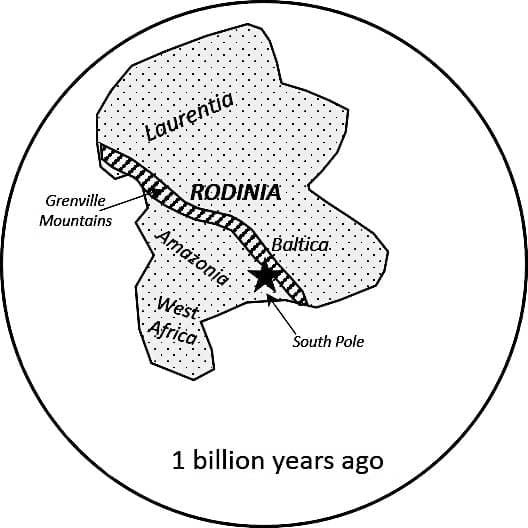 Rodinia
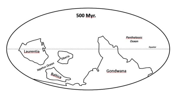
The paleogeography (the ancient land and sea configuration) of the Cambrian world was extraordinarily different from today. Using data from rocks and fossils around the globe, geologists know that the continents in the early Cambrian were all located primarily in the Southern Hemisphere, many close to the South Pole. Up until about 570 million years ago, ancestral North America, including the land that now encompasses Alabama, was part of the much larger “supercontinent” Rodinia. It formed near the South Pole about 1.1 billion years ago and began to break up into smaller continents just prior to the beginning of the Cambrian. By 570 million years ago, a landmass containing ancestral North America, known as Laurentia, had separated from Rodinia and began drifting north towards the equator. Unlike the modern continent, Laurentia was oriented almost 90 degrees clockwise from its current position, with the modern east coast of the United States and Canada forming Laurentia’s southern coast. This coast bordered a widening ocean basin known as Iapetus, with the largest fragment of Rodinia, referred to as Gondwana, lying on its opposite side. Other continents, including ancestral northern Europe (termed Baltica), lay generally south or east of Laurentia, across the Iapetus Ocean.
Rodinia
The paleogeography (the ancient land and sea configuration) of the Cambrian world was extraordinarily different from today. Using data from rocks and fossils around the globe, geologists know that the continents in the early Cambrian were all located primarily in the Southern Hemisphere, many close to the South Pole. Up until about 570 million years ago, ancestral North America, including the land that now encompasses Alabama, was part of the much larger “supercontinent” Rodinia. It formed near the South Pole about 1.1 billion years ago and began to break up into smaller continents just prior to the beginning of the Cambrian. By 570 million years ago, a landmass containing ancestral North America, known as Laurentia, had separated from Rodinia and began drifting north towards the equator. Unlike the modern continent, Laurentia was oriented almost 90 degrees clockwise from its current position, with the modern east coast of the United States and Canada forming Laurentia’s southern coast. This coast bordered a widening ocean basin known as Iapetus, with the largest fragment of Rodinia, referred to as Gondwana, lying on its opposite side. Other continents, including ancestral northern Europe (termed Baltica), lay generally south or east of Laurentia, across the Iapetus Ocean.
 Cambrian Laurentia
The breakup of Rodinia was largely complete prior to the start of the Cambrian. During the early Cambrian, however, a second rifting event separated a block of continental crust, or “microcontinent,” from the area now occupied by the Gulf of Mexico. Faults and volcanic rocks stretching from present-day Alabama to Oklahoma provide evidence for the Cambrian rift which followed the breakup of Rodinia.
Cambrian Laurentia
The breakup of Rodinia was largely complete prior to the start of the Cambrian. During the early Cambrian, however, a second rifting event separated a block of continental crust, or “microcontinent,” from the area now occupied by the Gulf of Mexico. Faults and volcanic rocks stretching from present-day Alabama to Oklahoma provide evidence for the Cambrian rift which followed the breakup of Rodinia.
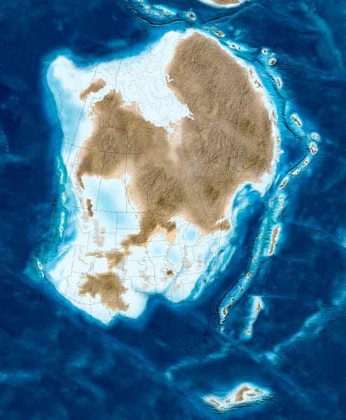
Geologists have had difficulty in reconstructing Cambrian Laurentia because its landscape has been obscured and altered by so many later geologic events. Geologic evidence, however, indicates marine waters covered nearly all of its relatively level landscape for most of the Cambrian. The central landmass was the last covered by the oceans, so more than likely it was higher than the surrounding area. In the warm, tropical waters off the southern coast of Laurentia, marine algae contributed massive amounts of mineral sediments composed primarily of calcium carbonate (CaCO).
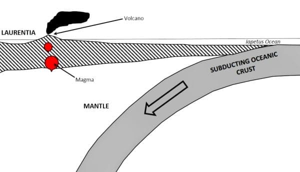 Iapetus Subduction
Near the end of the Cambrian, about 500 million years ago, a segment of Iapetus seafloor began sinking into Earth’s mantle through a process known as subduction, as shown in the diagram. This prevented Iapetus from expanding and created a band of volcanoes between the southern edge of Laurentia and the open ocean that remained active through the subsequent Ordovician Period. Lava flows and ash deposits erupting from these volcanoes are preserved in rocks of the Dadeville Complex, Ashland–Wedowee-Emuckfaw Belt, and Talladega Belt of east-central and southeastern Alabama. As Iapetus seafloor was consumed in the Earth’s mantle, the ocean basin between Laurentia and Gondwana shrank, eventually resulting in the continental collisions that formed the supercontinent Pangea and the Appalachian Mountains during the Permian Period.
Iapetus Subduction
Near the end of the Cambrian, about 500 million years ago, a segment of Iapetus seafloor began sinking into Earth’s mantle through a process known as subduction, as shown in the diagram. This prevented Iapetus from expanding and created a band of volcanoes between the southern edge of Laurentia and the open ocean that remained active through the subsequent Ordovician Period. Lava flows and ash deposits erupting from these volcanoes are preserved in rocks of the Dadeville Complex, Ashland–Wedowee-Emuckfaw Belt, and Talladega Belt of east-central and southeastern Alabama. As Iapetus seafloor was consumed in the Earth’s mantle, the ocean basin between Laurentia and Gondwana shrank, eventually resulting in the continental collisions that formed the supercontinent Pangea and the Appalachian Mountains during the Permian Period.
Cambrian Sedimentary Rocks
 Cambrian Geology of Alabama
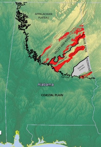
In Alabama, Cambrian sedimentary rocks are exposed in a band that stretches northeast-southwest in the northeastern part of the state, extending from Cherokee County in the northeast to Bibb County near the center of the state. This exposure, located in the Valley and Ridge Physiographic Section (shown with red highlights in the diagram), largely occupies a broad valley of the Coosa River bounded on either side by sizeable northwest-trending thrust faults. Although Cambrian rocks are present over a broad area of northeastern Alabama, the places where they appear at the surface are not uniform. Rock units in these areas are contained in separate fault-bounded blocks, which partly accounts for the discontinuous nature of the Cambrian exposures. This also holds true for Cambrian units within the Piedmont and Blue Ridge provinces, where rocks were subsequently altered by the tectonic events that produced the Appalachian Mountains, complicating interpretations of their environments of formation.
Cambrian Geology of Alabama
In Alabama, Cambrian sedimentary rocks are exposed in a band that stretches northeast-southwest in the northeastern part of the state, extending from Cherokee County in the northeast to Bibb County near the center of the state. This exposure, located in the Valley and Ridge Physiographic Section (shown with red highlights in the diagram), largely occupies a broad valley of the Coosa River bounded on either side by sizeable northwest-trending thrust faults. Although Cambrian rocks are present over a broad area of northeastern Alabama, the places where they appear at the surface are not uniform. Rock units in these areas are contained in separate fault-bounded blocks, which partly accounts for the discontinuous nature of the Cambrian exposures. This also holds true for Cambrian units within the Piedmont and Blue Ridge provinces, where rocks were subsequently altered by the tectonic events that produced the Appalachian Mountains, complicating interpretations of their environments of formation.
 Fossil Archeocyathids
Sedimentary rocks found in Alabama span the entire Cambrian, including rocks at both age extremes that can be difficult to distinguish from those of earlier or later periods. Overall, these deposits formed in marine waters that once covered the old continental core from the Iapetus Ocean on what is now the modern east coast of North America. Rocks from the lower Cambrian are mostly composed of coarse sands that formed from the weathering of earlier continental rocks. As the Cambrian progressed, the seas deepened over most of Laurentia (including present-day Alabama), and the rocks from this time period are largely carbonate rocks such as dolostone. The rocks of the middle Cambrian in Alabama also include fine-grained sediments (claystones and shales) that were deposited on the outer continental shelf and marine slope. These deposits contain most of the well-preserved fossils in the Cambrian of Alabama.
Fossil Archeocyathids
Sedimentary rocks found in Alabama span the entire Cambrian, including rocks at both age extremes that can be difficult to distinguish from those of earlier or later periods. Overall, these deposits formed in marine waters that once covered the old continental core from the Iapetus Ocean on what is now the modern east coast of North America. Rocks from the lower Cambrian are mostly composed of coarse sands that formed from the weathering of earlier continental rocks. As the Cambrian progressed, the seas deepened over most of Laurentia (including present-day Alabama), and the rocks from this time period are largely carbonate rocks such as dolostone. The rocks of the middle Cambrian in Alabama also include fine-grained sediments (claystones and shales) that were deposited on the outer continental shelf and marine slope. These deposits contain most of the well-preserved fossils in the Cambrian of Alabama.
There are a number of subdivisions and local formation names for Cambrian sedimentary deposits in Alabama, but four major sequences are typical. The lowermost, or oldest, Cambrian unit is the Chilhowee Group, largely composed of the Weisner Quartzite, which was deposited in streams and deltas on the continental shelf and named for Weisner Mountain in Cherokee County.
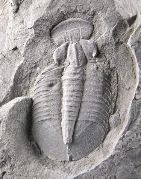
 Olenellid Trilobite
Above the Weisner is the Shady Dolomite. In Alabama, the Shady is generally represented by beds of iron-stained chert and other silicates derived from dissolution of the original carbonates. Early Cambrian archaeocyathids (shown above), the oldest carbonate-skeletal, reef-forming animals, are preserved in sedimentary rocks near the Sleeping Giants Mountains and the city of Talladega. They inhabited marine environments globally during the early Cambrian and went extinct by the early-middle Cambrian.
Olenellid Trilobite
Above the Weisner is the Shady Dolomite. In Alabama, the Shady is generally represented by beds of iron-stained chert and other silicates derived from dissolution of the original carbonates. Early Cambrian archaeocyathids (shown above), the oldest carbonate-skeletal, reef-forming animals, are preserved in sedimentary rocks near the Sleeping Giants Mountains and the city of Talladega. They inhabited marine environments globally during the early Cambrian and went extinct by the early-middle Cambrian.
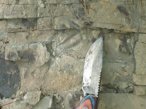
Above the Shady Dolomite is the Rome Formation, deposited through the rest of the early Cambrian and into the early-middle Cambrian. The type section (the location where the rock unit is originally identified) is in Rome, Georgia, opposite Cherokee County in Alabama. It is composed largely of red and green marine shales, sandstones, and thin limestones deposited on the edges of the continent from fine-grained weathered sediments that indicate their source was farther inland. This, in turn, indicates that the marine waters were deeper on the continental shelf when the Rome deposits occurred. Notably, olenellid trilobites, which serve as the index fossils (fossils that are used to correlate and date rock layers) for that age, have been found in rocks of the Rome Formation.
 Conasauga Formation Trilobites
The middle and lower upper Cambrian rock sequences are generally assigned to the Conasauga Formation, which occupies much of the Coosa Valley exposure, especially in Cherokee County around Weiss Reservoir. The type section of the Conasauga Formation is in the Conasauga River Valley in western Georgia, where it consists of thick mudstone deposits. In Alabama, the equivalent deposits are increasingly carbonates trending to the southwest and are also fairly thick. The Conasauga in Alabama includes marine shales, limestones, and dolostones, with many fossil-bearing beds. The Conasauga sediments formed in a wide variety of marine environments, ranging from the intertidal to the outer continental shelf.
Conasauga Formation Trilobites
The middle and lower upper Cambrian rock sequences are generally assigned to the Conasauga Formation, which occupies much of the Coosa Valley exposure, especially in Cherokee County around Weiss Reservoir. The type section of the Conasauga Formation is in the Conasauga River Valley in western Georgia, where it consists of thick mudstone deposits. In Alabama, the equivalent deposits are increasingly carbonates trending to the southwest and are also fairly thick. The Conasauga in Alabama includes marine shales, limestones, and dolostones, with many fossil-bearing beds. The Conasauga sediments formed in a wide variety of marine environments, ranging from the intertidal to the outer continental shelf.
The final Cambrian sequence includes thick dolostone beds that are largely assigned to the Copper Ridge Dolomite of the Knox Group. There are several dolostone sequences in Alabama that may lie between the Knox and Conasauga units, variously termed the Ketona, Brierfield, and Bibb Dolomites. In general, dolostone does not preserve fossils, so dolomite rocks are difficult to date and correlate among exposures.
Metamorphic Cambrian Rocks in Alabama

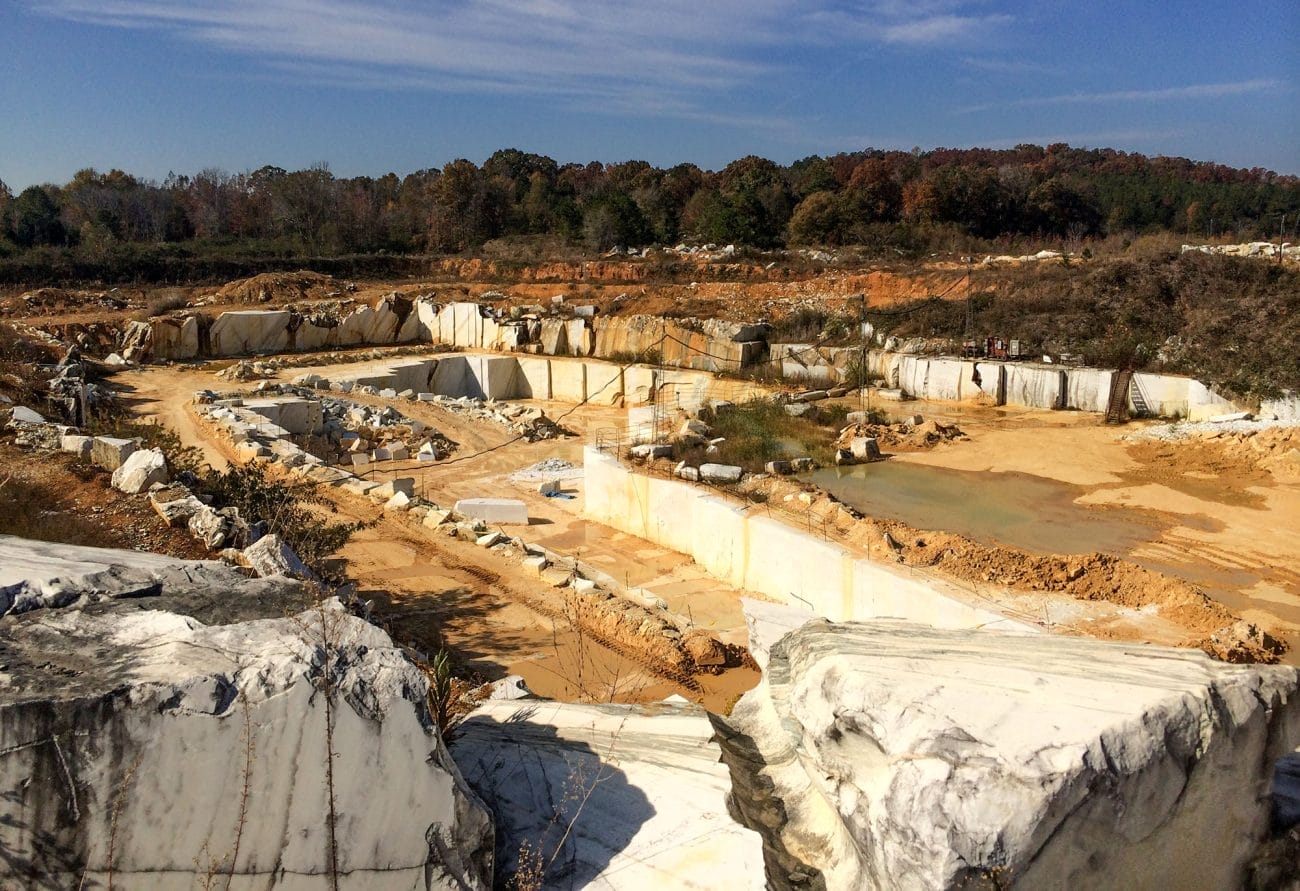
Sedimentary and other rocks that formed on the margin of Laurentia during the Cambrian were folded, faulted, and metamorphosed in a series of events that eventually produced the Appalachian Mountains in subsequent geologic periods. Cambrian metamorphic rocks of the Talladega Belt (named after the Talladega Mountains) stretch from just west of I-65 near the town of Jemison in Chilton County, northeast to the city of Anniston in Calhoun County, and then into Georgia towards the city of Cartersville in Bartow County. The sedimentary rocks from which these metamorphic slates, phyllites, and marbles formed were deposited in sedimentary environments similar to those of the Chilhowee, Shady, Rome, Conasauga, and Knox Groups to the northwest. Cambrian rocks of the Talladega belt include the Kahatchee Mountain and Sylacauga Marble Groups. The lower Sylacauga Marble Group is early Cambrian in age, based on the presence of archaeocyathids and trilobite fragments, indicating that the underlying Kahatchee Mountain Group dates to earlier Cambrian or older. The very thick Kahatchee Mountain Group is generally considered to be the metamorphic and temporal equivalent of the Chilhowee Group, indicating that it formed in coastal waters along the Laurentian shoreline of the Iapetus Ocean. Metamorphosed limestone of the Sylacauga Marble Group has been extensively studied because of its economic importance. Although prized as a building stone for its pure white color, the vast majority of marble mined from these rocks is used in the manufacture of paint, roofing material, cosmetics, stucco, and other industrial and commercial applications.
A second narrow belt of Cambrian metamorphic rocks makes up portions of the Ashland Supergroup, which stretches from the town of Clanton in Chilton County, northeast towards the community of Hightower in Randolph County. These Cambrian schists and gneisses were originally deposited as sandy muds off the continental slope and rise of the Iapetus coast. Economically valuable minerals of the Alabama Tin Belt, including cassiterite (SnO), or tin ore, are found in rocks of the lower Ashland Supergroup, which formed during the breakup of Rodinia. The third and final region of probable Cambrian metamorphic rocks in Alabama lies in the Pine Mountain belt (named for exposures near the town of Pine Mountain, Georgia). Rocks of this belt, including the Manchester Schist, Hollis Quartzite, and Chewacla Marble, are likely equivalents of Cambrian rocks in the Talladega Belt, Ashland-Wedowee-Emuckfaw belt, and the Valley and Ridge.
Cambrian Life and Fossils in Alabama
 Cambrian Inarticulate Brachiopod
As indicated by the descriptive term “Cambrian Explosion,” animal life in the Cambrian was significantly more advanced and diverse than in earlier ages, and it continued to diversify dramatically throughout the period. The ancestors of many higher animal groups, including sponges, arthropods, and annelid worms, were present by 600 million years ago, but evidence for them is from atypical sources, such as tracks and embryo fossils. Scientists have proposed several hypotheses to explain the apparently sudden appearance of skeletonized higher life in the Cambrian, including an “arms race” of protective armor and spines, changes in ocean chemistry (all Cambrian fossils are marine), and an increase in oxygen in the atmosphere and ocean. Because nearly all animal skeletal minerals include a lot of oxygen, this last hypothesis is in current favor. In addition to explaining the appearance of larger skeletons, increasing oxygen levels would also allow burrowing animals to delve deeper into submarine sediments and thereby expand habitable areas of the ocean. Fossils of a wide variety of photosynthetic algae are abundant in the Cambrian, and many Cambrian rocks are composed primarily of algal structures. Therefore, it is reasonable to assume that photosynthesis was a cause of increasing oxygen levels in the atmosphere.
Cambrian Inarticulate Brachiopod
As indicated by the descriptive term “Cambrian Explosion,” animal life in the Cambrian was significantly more advanced and diverse than in earlier ages, and it continued to diversify dramatically throughout the period. The ancestors of many higher animal groups, including sponges, arthropods, and annelid worms, were present by 600 million years ago, but evidence for them is from atypical sources, such as tracks and embryo fossils. Scientists have proposed several hypotheses to explain the apparently sudden appearance of skeletonized higher life in the Cambrian, including an “arms race” of protective armor and spines, changes in ocean chemistry (all Cambrian fossils are marine), and an increase in oxygen in the atmosphere and ocean. Because nearly all animal skeletal minerals include a lot of oxygen, this last hypothesis is in current favor. In addition to explaining the appearance of larger skeletons, increasing oxygen levels would also allow burrowing animals to delve deeper into submarine sediments and thereby expand habitable areas of the ocean. Fossils of a wide variety of photosynthetic algae are abundant in the Cambrian, and many Cambrian rocks are composed primarily of algal structures. Therefore, it is reasonable to assume that photosynthesis was a cause of increasing oxygen levels in the atmosphere.
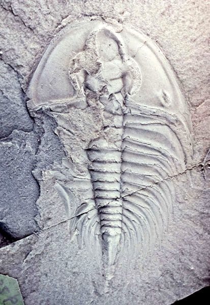
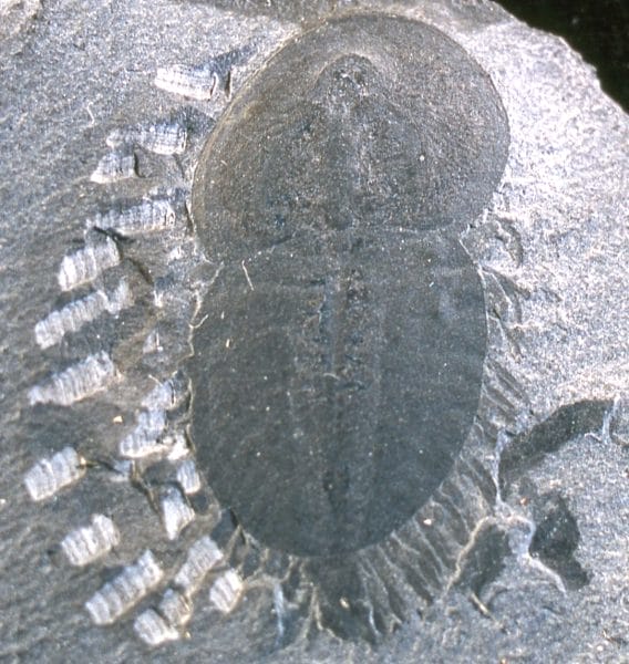
 Cambrian Ptychopariid Trilobite
The oldest and most recognizable skeletonized animals in Cambrian deposits are trilobites, which are both showy and ubiquitous. There are literally thousands of Cambrian trilobite species described, and it is apparent that they were the dominant life forms in Cambrian seas. For this reason, they are also the oldest fossils regularly used for dating and correlating rocks. Some Cambrian trilobites in Alabama, such as the one shown here, are traceable across Laurentia to the western continent and others can be traced across the ancient oceans to northern Europe and China. Trilobites are among the most prized fossils for collectors, and Alabama has some of the finest representatives of many groups.
Cambrian Ptychopariid Trilobite
The oldest and most recognizable skeletonized animals in Cambrian deposits are trilobites, which are both showy and ubiquitous. There are literally thousands of Cambrian trilobite species described, and it is apparent that they were the dominant life forms in Cambrian seas. For this reason, they are also the oldest fossils regularly used for dating and correlating rocks. Some Cambrian trilobites in Alabama, such as the one shown here, are traceable across Laurentia to the western continent and others can be traced across the ancient oceans to northern Europe and China. Trilobites are among the most prized fossils for collectors, and Alabama has some of the finest representatives of many groups.
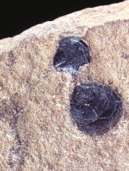
In addition to trilobites, scientific research has uncovered less-complex skeletal animals below the lowest Cambrian beds containing trilobites, dating to approximately 541 to 520 million years ago. Among the most notable are the archaeocyathids, inarticulate brachiopods, and a wide variety of small shelled animals that have yet to be identified. The Cambrian Period was a time of increasing biological variation among marine animals, but so far there are no known Cambrian land animals and there is no definitive evidence of land plants.
 Naraoia compacta
Many higher animal groups, which are major components of the later Paleozoic fossil record, are also known from the Cambrian. These include sponges, articulate brachiopods, gastropods (snails), and nautiloid cephalopods. There are fossil reefs from the Cambrian, but they were deposited by blue-green, red, and green algae, rather than the carbonate reef-forming groups of the later Paleozoic that include corals, bryozoans, and stromatoporoids.
Naraoia compacta
Many higher animal groups, which are major components of the later Paleozoic fossil record, are also known from the Cambrian. These include sponges, articulate brachiopods, gastropods (snails), and nautiloid cephalopods. There are fossil reefs from the Cambrian, but they were deposited by blue-green, red, and green algae, rather than the carbonate reef-forming groups of the later Paleozoic that include corals, bryozoans, and stromatoporoids.
Many other types of animals existed in the Cambrian, but they are not commonly found as fossils because they lacked hard skeletons. Evidence of their existence is scattered around the world in fossil sites where impressions of soft tissue have been preserved, such as the famous middle-Cambrian Burgess Shale of Alberta, Canada, which popularized the term “Cambrian Explosion.” Soft-bodied fossils include various worms, crustaceans, and many other arthropods; unique animals including three-foot-long anomalocarids, algae, and even relatives of vertebrates. None of these deposits have been found in Alabama, however, but there are some nearby in the Melson community in Georgia, opposite Cherokee County, including a soft-skeletoned trilobite genus, Naraoia (shown at right).
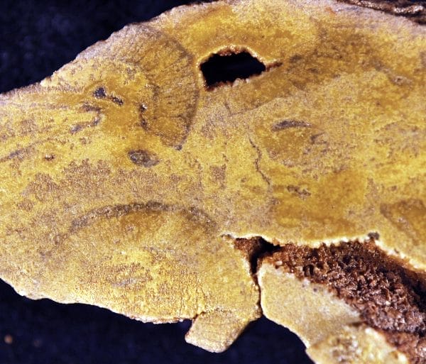
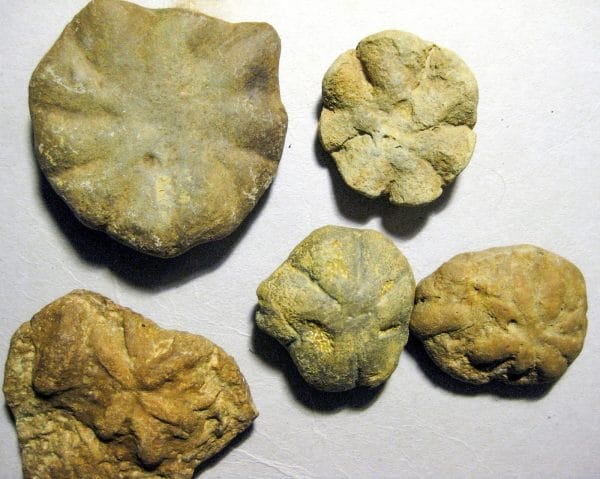 Brooksella Fossils
Among the unique aspects of the Cambrian in Alabama is the abundance of a strange group of fossils in the Conasauga Formation termed Brooksella. These were first described by Charles Walcott in 1896 and identified as fossil jellyfish, because many do resemble the bells of medusoid jellyfish. Over the years, however, it has become accepted that jellyfish would never preserve in such a way, and multiple researchers have attempted to identify the nature of Brooksella (and a related generic name Laotira). Among more recent interpretations is that these multi-lobed objects represent feeding traces of an indeterminate soft-bodied invertebrate. Another current hypothesis is that at least some of these fossils are an extinct form of sponge.
Brooksella Fossils
Among the unique aspects of the Cambrian in Alabama is the abundance of a strange group of fossils in the Conasauga Formation termed Brooksella. These were first described by Charles Walcott in 1896 and identified as fossil jellyfish, because many do resemble the bells of medusoid jellyfish. Over the years, however, it has become accepted that jellyfish would never preserve in such a way, and multiple researchers have attempted to identify the nature of Brooksella (and a related generic name Laotira). Among more recent interpretations is that these multi-lobed objects represent feeding traces of an indeterminate soft-bodied invertebrate. Another current hypothesis is that at least some of these fossils are an extinct form of sponge.
Further Reading
- Barineau, C. I., J. F. Tull, and C. S. Holm-Denoma. “A Laurentian Margin Back-Arc: The Ordovician Wedowee-Emuckfaw-Dahlonega Basin.” In Diverse Excursions in the Southeast: Paleozoic to Present, edited by Ann E. Holmes, pp. 21-78. Field Guide 39. Boulder, Colo.: Geological Society of America, 2015.
- Johnson, L. W., and J. F. Tull. “Sylacauga Marble Group: Distal Fragment of the Southern Appalachian Cambrian-Ordovician Carbonate Platform.” Southeastern Geology 41 (January 2002):75-102.
- Osborne, W. E., W. A. Thomas, and R. A. Astini, eds. The Conasauga Formation and Equivalent Units in the Appalachian Thrust Belt in Alabama. Guidebook for the 37th Annual Field Trip. Tuscaloosa: Alabama Geological Society, 2000.
- Schwimmer, D. R. “Taxonomy and Biostratigraphy of Some Middle Cambrian Trilobites from the Conasauga Formation in Western Georgia.” Journal of Paleontology 63 (July 1989): 484-94.
- Schwimmer, D. R., and W. M. Montante. “Exceptional Fossils Preservation in the Conasauga Formation, Cambrian, Northwestern Georgia, USA.” Palaios 22 (July 2007): 360-72.
- Tull, J.F., and C.I. Barineau. “Overview of the Stratigraphic and Structural Evolution of the Talladega Slate Belt, Alabama Appalachians.” In From the Blue Ridge to the Coastal Plain: Field Excursions in the Southeastern United States, edited by M. C. Eppes and M. J. Bartholomew, pp. 263-302. Field Guide 29. Boulder, Colo.: Geological Society of America, 2012.