Highland Rim Physiographic Section
 Location of the Highland Rim Section
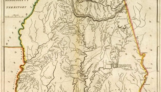
The Highland Rim section is the southernmost section of the Interior Low Plateaus province in the Appalachian Highlands Region. It is one of Alabama’s five physiographic sections, each of which is recognized by its unique pattern of relief features or landforms. The Highland Rim is the northernmost and the smallest physiographic section in Alabama, occupying about 7 percent of the state. It occurs as a roughly rectangular area in northwest and north central Alabama, including Lauderdale, Limestone, Madison, Colbert, Lawrence and Morgan Counties, and continues northward into central Tennessee and Kentucky. It is bordered by the Cumberland Plateau to the southeast and the East Gulf Coastal Plain to the southwest. The landscape consists of a prominent east-west-trending ridge separating two valleys. Elevations reach about 900 feet along the Alabama-Tennessee border and drop to about 420 feet where the Tennessee River flows back into Tennessee.
Location of the Highland Rim Section
The Highland Rim section is the southernmost section of the Interior Low Plateaus province in the Appalachian Highlands Region. It is one of Alabama’s five physiographic sections, each of which is recognized by its unique pattern of relief features or landforms. The Highland Rim is the northernmost and the smallest physiographic section in Alabama, occupying about 7 percent of the state. It occurs as a roughly rectangular area in northwest and north central Alabama, including Lauderdale, Limestone, Madison, Colbert, Lawrence and Morgan Counties, and continues northward into central Tennessee and Kentucky. It is bordered by the Cumberland Plateau to the southeast and the East Gulf Coastal Plain to the southwest. The landscape consists of a prominent east-west-trending ridge separating two valleys. Elevations reach about 900 feet along the Alabama-Tennessee border and drop to about 420 feet where the Tennessee River flows back into Tennessee.
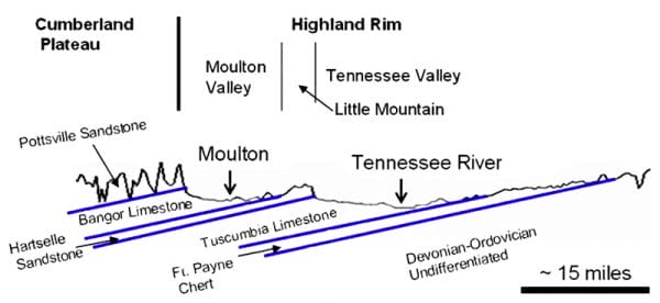 Highland Rim District Cross-Section
The landforms found in the Highland Rim are the result of differential erosion of the underlying rocks. These rocks consist of middle- to upper-Paleozoic sedimentary rocks (490 to 323 million years before the present), most of which formed during the Mississippian period (353 to 323 million years before the present). The main ridge-forming rock is known as the Hartselle Sandstone, and the valleys cut through the Bangor Limestone and Tuscumbia Limestone Formations.
Highland Rim District Cross-Section
The landforms found in the Highland Rim are the result of differential erosion of the underlying rocks. These rocks consist of middle- to upper-Paleozoic sedimentary rocks (490 to 323 million years before the present), most of which formed during the Mississippian period (353 to 323 million years before the present). The main ridge-forming rock is known as the Hartselle Sandstone, and the valleys cut through the Bangor Limestone and Tuscumbia Limestone Formations.
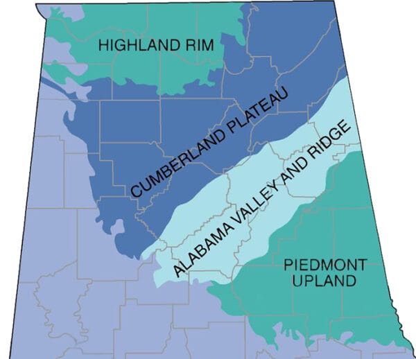
Districts
The Highland Rim is comprised of three districts: the Tennessee Valley, Little Mountain, and the Moulton Valley.
The Tennessee Valley district occupies most of the Highland Rim, stretching north from the base of the northern face of Little Mountain to the Tennessee border. The floor of the valley ranges from 15 to 23 miles wide. Elevations increase moving north from the river to the Tennessee border because the underlying chert-bearing limestones north of Athens, Limestone County, are more resistant to weathering than those to the south of the city.
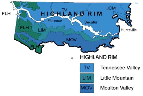 Highland Rim Districts
Little Mountain forms the northern border of Moulton Valley. It begins south of Huntsville, in Madison County, on the southern bank of the Tennessee River and continues to just northwest of Russellville, in Franklin County, where it has been buried beneath the East Gulf Coastal Plain. It reaches elevations of about 840 feet in Lawrence County. Little Mountain is a cuesta, meaning that the ridge slopes steeply on one side and more gently on the other as a result of the direction of dip of the underlying rock formations.
Highland Rim Districts
Little Mountain forms the northern border of Moulton Valley. It begins south of Huntsville, in Madison County, on the southern bank of the Tennessee River and continues to just northwest of Russellville, in Franklin County, where it has been buried beneath the East Gulf Coastal Plain. It reaches elevations of about 840 feet in Lawrence County. Little Mountain is a cuesta, meaning that the ridge slopes steeply on one side and more gently on the other as a result of the direction of dip of the underlying rock formations.
Moulton Valley, which formed in the Bangor Limestone, separates the Warrior Basin of the Cumberland Plateau from Little Mountain. The valley narrows from about eight miles wide in the east, in the vicinity of Hartselle, to less than three miles wide in the west, south of Russellville. The valley’s southern border is a steep sandstone cliff face, or scarp, bordering the Warrior Basin that rises 400 feet above the valley floor. To the north, the valley wall tops out at about 300 feet.
The Tennessee River
 Colbert Fossil Plant
The Tennessee River flows through the valley in a northwesterly direction, and its small tributaries flow from Little Mountain and the northern uplands into the main river. Throughout most of its course, the Tennessee flows wide and deep in its own alluvium, which is the loose material deposited by the river when it floods. Prior to construction of Wilson and Wheeler Dams, the river consisted of rapids, shoals, and shallow water from present-day Florence to Decatur, where it cut through the Tuscumbia Limestone and struck the more resistant Fort Payne Chert. In 1924, Wilson Dam and its locks were completed at Florence, and in 1936 Wheeler Dam and its locks were completed upstream, thus making the Tennessee River navigable. The Tennessee Valley Authority (TVA) operates three hydroelectric plants on the river, and the two largest plants in the state, the Wheeler and the Wilson plants, lie within the Highland Rim section.
Colbert Fossil Plant
The Tennessee River flows through the valley in a northwesterly direction, and its small tributaries flow from Little Mountain and the northern uplands into the main river. Throughout most of its course, the Tennessee flows wide and deep in its own alluvium, which is the loose material deposited by the river when it floods. Prior to construction of Wilson and Wheeler Dams, the river consisted of rapids, shoals, and shallow water from present-day Florence to Decatur, where it cut through the Tuscumbia Limestone and struck the more resistant Fort Payne Chert. In 1924, Wilson Dam and its locks were completed at Florence, and in 1936 Wheeler Dam and its locks were completed upstream, thus making the Tennessee River navigable. The Tennessee Valley Authority (TVA) operates three hydroelectric plants on the river, and the two largest plants in the state, the Wheeler and the Wilson plants, lie within the Highland Rim section.
Natural Resources
Numerous quarries extract limestone from both the Tuscumbia and Bangor Formations. Except for one quarry, which produces dimension stone used for architectural and decorative purposes, the limestone is used as construction aggregate.
Further Reading
- Adams, G. I., et al. Geology of Alabama. Geological Survey of Alabama Special Report 14. Tuscaloosa, Ala.: Geological Survey of Alabama, 1926.
- Lacefield, J. Lost Worlds in Alabama Rocks. Tuscaloosa: Alabama Museum of Natural History, 2013.
- Pashin, J. C. “New Perspectives on the Mississippian System.” Geological Society of Alabama Guidebook 30. Tuscaloosa: Geological Society of Alabama, 1993.