Jurassic Period
 Early Jurassic Landscape Reconstruction
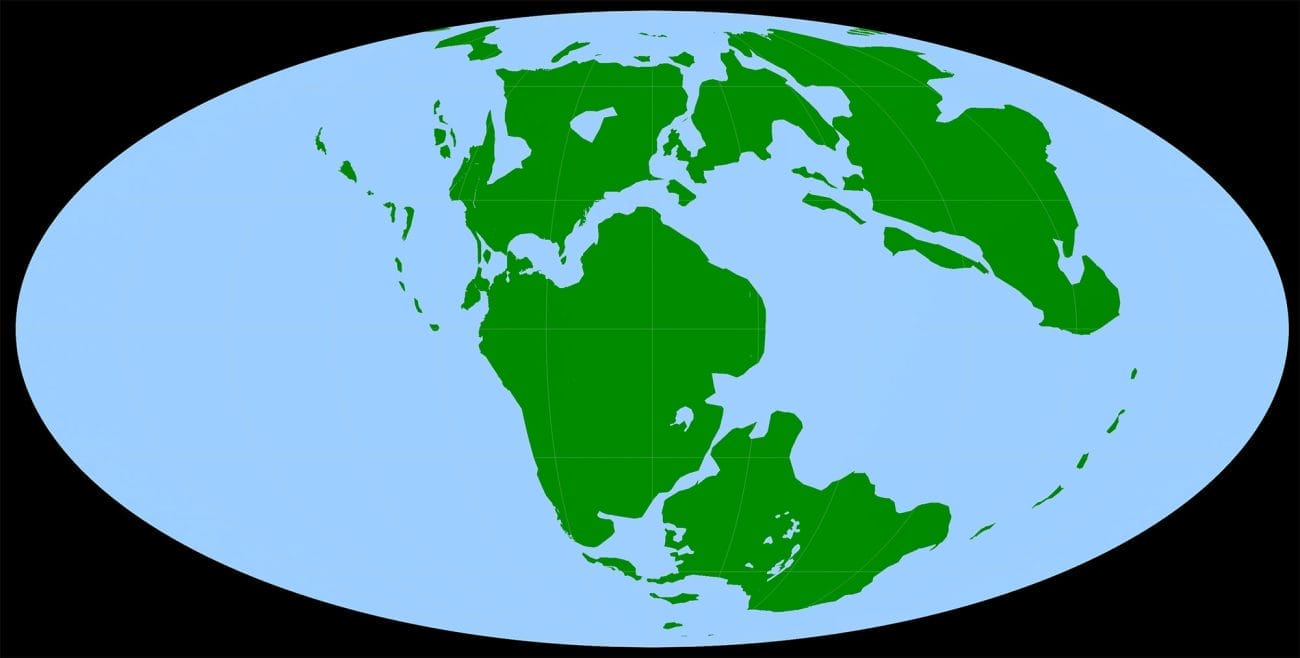
The Jurassic Period (roughly 200 million years ago to 146 million years ago) is the middle part of the Mesozoic era. This period, often called the Age of Dinosaurs, began when all of the present-day continents were loosely connected in a supercontinent known as Pangaea set within a giant sea known as Panthalassa. The Jurassic is notable for the oldest known birds and the oldest large dinosaurs, as well as being the period when Pangaea, which had existed for 100 million years, began to break apart. Isolated cracks in the supercontinent formed during the Triassic and the early part of the Jurassic and widened during the Middle Jurassic, eventually forming a large body of water (the early Gulf of Mexico) that was still mostly isolated from the world ocean. By the Late Jurassic, the Gulf was open to the Pacific (the former Panthalassa) to the west and the new Atlantic ocean to the east via narrow straits.
Early Jurassic Landscape Reconstruction
The Jurassic Period (roughly 200 million years ago to 146 million years ago) is the middle part of the Mesozoic era. This period, often called the Age of Dinosaurs, began when all of the present-day continents were loosely connected in a supercontinent known as Pangaea set within a giant sea known as Panthalassa. The Jurassic is notable for the oldest known birds and the oldest large dinosaurs, as well as being the period when Pangaea, which had existed for 100 million years, began to break apart. Isolated cracks in the supercontinent formed during the Triassic and the early part of the Jurassic and widened during the Middle Jurassic, eventually forming a large body of water (the early Gulf of Mexico) that was still mostly isolated from the world ocean. By the Late Jurassic, the Gulf was open to the Pacific (the former Panthalassa) to the west and the new Atlantic ocean to the east via narrow straits.

The area that would become Alabama lay closer to the equator than it does today, and the southern part of the state was submerged by the waters of the young Gulf by late Middle Jurassic time. The Jurassic shoreline shifted back and forth over hundreds of miles as sea levels and rates of sediment deposition fluctuated, but it remained north of Alabama’s current shoreline. Thus, a given spot might have been sea floor during the Middle Jurassic, desert during the early Late Jurassic, and submerged again toward the end of the Jurassic. Parts of Alabama that were submerged during at least part of the Jurassic include the areas of present-day Choctaw, Washington, Mobile, Baldwin, Clarke, Monroe, Conecuh, Escambia, and Covington counties. The updip limit of the Smackover Formation approximates the Jurassic high water mark. The highest shoreline probably was not preserved everywhere, so the true high water mark, if it could be located, most likely would be slightly farther north and east.
During the Jurassic, the Gulf of Mexico evolved from a series of narrow valleys to something approaching its present configuration, growing wider and deeper as a result of plate tectonics. Initially, a giant crack opened in the ocean crust between the southeastern United States and the present-day Yucatán Peninsula of Mexico and continued to spread. New seafloor formed on both sides of the crack and gradually pushed the Yucatán and the southern United States apart. The Gulf also was connected intermittently to the Atlantic and Pacific oceans, which were its main sources of water. Additional water entered the Gulf through rivers, which carried sediment from the continental inland that settled on the floor and started to fill the basin even as it was still opening. This process continues today, with the most important source of terrestrial sediment in the modern Gulf being the Mississippi River.
The Jurassic Environment
 Anhydrite
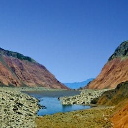
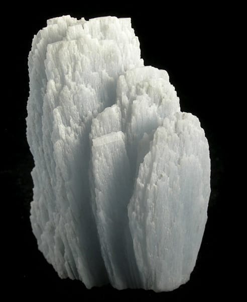
All preserved Jurassic rocks in Alabama are located far underground and were deposited in or next to the ancient Gulf of Mexico. Because they are buried so deep, scientists do not know much about what life was like on land at that time. They do know that the Jurassic landscape was hot and dry even by the shore because they have found a large amount of the white mineral anhydrite. Both anhydrite and the similar mineral gypsum are formed when intense evaporation occurs just below the sediment surface and in shallow salty ponds. A modern example of this type of environment can be found in the Arabian Gulf of the Middle East and around the Red Sea.
Anhydrite
All preserved Jurassic rocks in Alabama are located far underground and were deposited in or next to the ancient Gulf of Mexico. Because they are buried so deep, scientists do not know much about what life was like on land at that time. They do know that the Jurassic landscape was hot and dry even by the shore because they have found a large amount of the white mineral anhydrite. Both anhydrite and the similar mineral gypsum are formed when intense evaporation occurs just below the sediment surface and in shallow salty ponds. A modern example of this type of environment can be found in the Arabian Gulf of the Middle East and around the Red Sea.
Alabama’s proximity to the equator during the Jurassic meant that there were no pronounced seasonal changes like today. Rather, the climate was consistently hot and dry, much like the deserts of the American southwest, despite being near the coast. Daily high temperatures often exceeded 100°F, but the dry climate made for cooler nights. Areas near the coast would have been affected by concentrated salt water, a source of additional physiological stress for most organisms. Little is known of the landscape or appearance of Jurassic-era Alabama. Most animals and plants able to survive in this environment were like those found in modern deserts, with some conspicuous absences. For instance, flowering plants had not yet evolved, so the familiar cacti would not have existed. Various kinds of small conifers grow in some modern deserts, and a few conifer fossils have been found in Jurassic desert deposits. Lichens and cyanobacteria tolerate extreme conditions and even live inside rocks; both of these groups were probably represented in Alabama’s Jurassic deserts. Jurassic mammals were likely unable to survive in such extreme environments. Jurassic rocks that formed in semiarid environments in other parts of North America contain fossils of small dinosaurs and pterosaurs. Depending on how much water was available, some of these could have lived in Alabama during the Jurassic. Lizards are abundant and diverse in modern deserts and probably could have lived in Alabama during the Jurassic, but none of their fossils have been found. The same is true of arthropods that are adapted for life in arid climates, such as specialized scorpions, spiders, flies, ants, termites, and beetles. Snakes have not been found in Jurassic rocks and may not have evolved until later. Lungfish and birds may possibly have been regular visitors. Small temporary ponds might have been home to clams and snails, algae and horsetails, and ostracodes (like tiny shelled shrimp).
The Jurassic belongs to the period of Earth’s history popularly known as the Age of Dinosaurs, and indeed dinosaur fossils are found in Alabama. However, it is unlikely that many dinosaurs ever lived in the hot, salty, dry environment of Alabama during the Jurassic. Too little food would have been available to support any but the smallest dinosaurs. As a modern-day example, elephants eat an average of 450 pounds of food per day and weigh up to 11 tons. Large herbivorous dinosaurs weighed up to 90 tons. If their appetites were proportional, then they consumed eight times as much as elephants, or 3,600 pounds of food per day. Scientists theorize that the dinosaur fossils found in Alabama are likely the result of deposition in the marine environment. More specifically, a dinosaur that died near a water source was most likely carried downriver to the sea, where it was scavenged by sea creatures, explaining why few complete skeletons have been found.
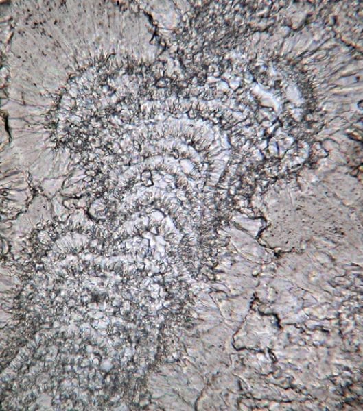 Calcimicrobe
Much like the terrestrial environment, the waters of the Jurassic Southeast were inhospitable as well. The Gulf of Mexico was filled with toxic brine during most of the Middle Jurassic and did not improve much until the Cretaceous. The waters that frequently covered what is now southwest Alabama were the saltiest and most inhospitable. The environment consisted of three partially separated basins that were generally isolated from the main part of the Gulf. Their waters were shallow, hot, and so salty that only a very few creatures could survive: burrowing shrimp, a few small clams, sponges, worms, and cyanobacteria (also called blue-green algae). Rare fossils of sea urchins and corals hint at brief periods when living conditions were less extreme. Outside the Gulf, Panthalassa was home to all sorts of giant fish and marine reptiles, but there is no evidence that any of them made it into Alabama’s Jurassic Gulf.
Calcimicrobe
Much like the terrestrial environment, the waters of the Jurassic Southeast were inhospitable as well. The Gulf of Mexico was filled with toxic brine during most of the Middle Jurassic and did not improve much until the Cretaceous. The waters that frequently covered what is now southwest Alabama were the saltiest and most inhospitable. The environment consisted of three partially separated basins that were generally isolated from the main part of the Gulf. Their waters were shallow, hot, and so salty that only a very few creatures could survive: burrowing shrimp, a few small clams, sponges, worms, and cyanobacteria (also called blue-green algae). Rare fossils of sea urchins and corals hint at brief periods when living conditions were less extreme. Outside the Gulf, Panthalassa was home to all sorts of giant fish and marine reptiles, but there is no evidence that any of them made it into Alabama’s Jurassic Gulf.
Jurassic Rock Units
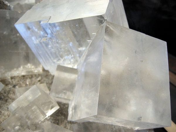 Rock Salt
Sedimentary rock begins as sediment that is deposited in particular places and with particular characteristics. For example, a river carries sand and mud along its course, and the heavier sand grains are deposited in the long, sinuous riverbed. The mud, however, is deposited on the floodplain when the river overtops its banks. Rock produced from such an event exists as a huge mass of shale containing sinuous bodies of sandstone. These bodies of rock that have consistent characteristics and common origin are given official names by scientists so that they can talk about them. In Alabama’s Jurassic rocks, the Norphlet Sandstone (formed in a desert) is mostly made of sandstone, and the Louann Salt (precipitated in a very salty basin) is mostly rock salt. Geologists also name rocks according to their age, and in the Jurassic, rock formations are assigned to the Early, Middle, and Late Jurassic.
Rock Salt
Sedimentary rock begins as sediment that is deposited in particular places and with particular characteristics. For example, a river carries sand and mud along its course, and the heavier sand grains are deposited in the long, sinuous riverbed. The mud, however, is deposited on the floodplain when the river overtops its banks. Rock produced from such an event exists as a huge mass of shale containing sinuous bodies of sandstone. These bodies of rock that have consistent characteristics and common origin are given official names by scientists so that they can talk about them. In Alabama’s Jurassic rocks, the Norphlet Sandstone (formed in a desert) is mostly made of sandstone, and the Louann Salt (precipitated in a very salty basin) is mostly rock salt. Geologists also name rocks according to their age, and in the Jurassic, rock formations are assigned to the Early, Middle, and Late Jurassic.
Jurassic rock formations in Alabama and surrounding Gulf states are not exposed at the surface. They were laid down close to sea level in lagoons, deserts, and other near-shore marine and terrestrial settings and have since been buried by up to 22,000 feet of younger deposits. Even the uppermost and therefore youngest layer of Jurassic rocks (the lower Cotton Valley Group) in Alabama is still almost a mile below the surface. The coastal plain continues to thicken as Alabama’s rivers carry sediment from mountains and plateaus in the northern part of the state as well as neighboring states and deposit it further south. The weight of this overlying sediment has been pushing down on Alabama’s Jurassic deposits for 146 million years.
Present-day Alabama’s economy benefits from this geology. The structure of Alabama’s Jurassic rocks, combined with the pressure and temperature of deep long-term burial, has generated significant deposits of oil and gas from organic material in the Jurassic sediment. In fact, Alabama ranks fifteenth among the states in crude oil production. The Smackover Formation is Alabama’s most important oil-producing unit and is responsible for a significant portion of the state’s income. The state ranks eleventh in natural gas production, roughly half of which comes from the Jurassic Norphlet Formation.
Formation of Jurassic Rocks
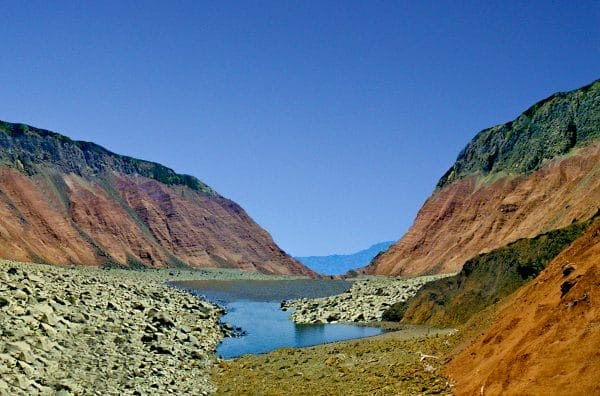
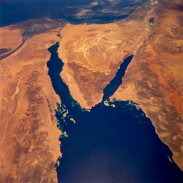 Red Sea Environment
As noted earlier, the Gulf of Mexico began to open during the Triassic, sometime between 230 and 200 million years ago. Initially, narrow rift valleys opened in the Earth as Mexico and the United States were torn apart. The rocks dating to this period consist of complex mixtures of river, floodplain, lake, and other terrestrial deposits, as well as some near-shore marine units. Although these Triassic rocks are not exposed anywhere in Alabama, similar Triassic valley fills occur on the surface in many Atlantic states. Alabama’s Eagle Mills Formation, which formed at this time, is buried deep below the surface of south Alabama. Some of these valley fill deposits may be as young as the Early Jurassic.
Red Sea Environment
As noted earlier, the Gulf of Mexico began to open during the Triassic, sometime between 230 and 200 million years ago. Initially, narrow rift valleys opened in the Earth as Mexico and the United States were torn apart. The rocks dating to this period consist of complex mixtures of river, floodplain, lake, and other terrestrial deposits, as well as some near-shore marine units. Although these Triassic rocks are not exposed anywhere in Alabama, similar Triassic valley fills occur on the surface in many Atlantic states. Alabama’s Eagle Mills Formation, which formed at this time, is buried deep below the surface of south Alabama. Some of these valley fill deposits may be as young as the Early Jurassic.
By sometime in the Middle Jurassic, the valleys had expanded and merged to form the early Gulf of Mexico. During this time, the Gulf occasionally became isolated from the oceans, and intense evaporation in the hot dry climate caused the sea water to become highly concentrated. Each time the Gulf opened, fresh seawater diluted the concentrated seawater. At a certain level of concentration, the minerals commonly found in seawater began to crystallize, and anhydrite, salt, and sometimes other minerals were deposited. These deposits, some as much as a mile thick in places, are now called the Werner Anhydrite, the Louann Salt, and the Pine Hills Anhydrite.
 Norphlet Formation Sandstone
By the early Late Jurassic, the salt deposits began to become buried by the sands of a coastal desert that formed what is now the Late Jurassic Norphlet Sandstone. These deposits are typical of desert environments, displaying thick bands composed of thin, even layers that are parallel to one another but steeply inclined. These dune deposits are associated with horizontal layers that were laid down between the dunes, including some that formed in small temporary ponds. Coastal marine deposits are widespread but thin in the uppermost part of the Norphlet. During this time, rising waters filled the Gulf and formed a shallow tropical sea that covered the sand deposits of the Norphlet and remained subject to significant evaporation in the arid climate. The deposits of this period are made up primarily of limestone and dolomite of the Smackover Formation. The best-known Smackover deposits consist of ooids: tiny spheres of limestone that form in warm, agitated salt water.
Norphlet Formation Sandstone
By the early Late Jurassic, the salt deposits began to become buried by the sands of a coastal desert that formed what is now the Late Jurassic Norphlet Sandstone. These deposits are typical of desert environments, displaying thick bands composed of thin, even layers that are parallel to one another but steeply inclined. These dune deposits are associated with horizontal layers that were laid down between the dunes, including some that formed in small temporary ponds. Coastal marine deposits are widespread but thin in the uppermost part of the Norphlet. During this time, rising waters filled the Gulf and formed a shallow tropical sea that covered the sand deposits of the Norphlet and remained subject to significant evaporation in the arid climate. The deposits of this period are made up primarily of limestone and dolomite of the Smackover Formation. The best-known Smackover deposits consist of ooids: tiny spheres of limestone that form in warm, agitated salt water.
The Haynesville Formation, which overlies the Smackover, was deposited in a system of salty lagoons, shallow seas, and associated coastal environments and combines characteristics of all three underlying units. It consists of layers of rock salt, limestone, mudstone, and sandstone that reflect the shifting coastline and varying degrees of evaporation in waters of the Gulf margin. The hot dry climate prevalent while the Haynesville Formation was being deposited was deadly to most life, and few fossils are found. The fauna and flora of the Haynesville was probably much like that of the better-known Smackover Formation.
The youngest Jurassic rocks in Alabama belong to the lower Cotton Valley Group. They are dominated by sandstones deposited in rivers that shifted back and forth across the margins of the shrinking Gulf. These rocks record the vigorous development and action of sandy-bottomed rivers in a climate that had become slightly wetter. Much less is known about the Haynesville and Cotton Valley formations as fewer rock cores have been collected from the two younger units than from the underlying oil- and gas-rich Norphlet and Smackover formations.
Further Reading
- Lacefield, Jim. Lost Worlds in Alabama Rocks: A Guide. Birmingham: Alabama Geological Society, 2000.
- Mann, S. D., and D. C. Kopaska-Merkel. Depositional History of the Smackover-Buckner Transition, Eastern Mississippi Interior Salt Basin. Volume 42 of Transactions of the Gulf Coast Association of Geological Societies. Austin, Texas: GCAGS, 1992.