Alabama's Climate
Alabama’s generally warm, humid climate results from its mid-latitude location and proximity to the Gulf of Mexico. This location also produces the often-turbulent weather patterns that regularly bring tornadoes and hurricanes to the state. Located within the Humid Subtropical region in the Koppen classification system, Alabama’s climate is characterized by relatively mild winters, hot summers, and year-round precipitation.
 Tornado in Marshall County
One of the most important factors in determining Alabama’s climate patterns is its mid-latitude location (the boundaries of the state extend from approximately 30° to 35° north latitude and 85° to 88.5° west longitude). This location, in conjunction with the Earth’s orbit around the Sun and its axial tilt of 23.5° relative to the Sun, produces variations in day length and temperature patterns throughout the year that result in an annual cycle of four distinct seasons. For example, day length for the city of Montgomery, Montgomery County, which is located near the geographic center of the state, varies from a minimum of approximately 10 hours in December to a maximum of approximately 14 hours in June. Montgomery’s average minimum daily temperature in January is approximately 35.8° F and its average maximum daily temperature in July is approximately 93° F. The highest temperature reported in the state appears to be 112° F at Centreville, Bibb County, on September 5, 1925, and the lowest appears to be -27° F at New Market, Madison County, on January 30, 1966.
Tornado in Marshall County
One of the most important factors in determining Alabama’s climate patterns is its mid-latitude location (the boundaries of the state extend from approximately 30° to 35° north latitude and 85° to 88.5° west longitude). This location, in conjunction with the Earth’s orbit around the Sun and its axial tilt of 23.5° relative to the Sun, produces variations in day length and temperature patterns throughout the year that result in an annual cycle of four distinct seasons. For example, day length for the city of Montgomery, Montgomery County, which is located near the geographic center of the state, varies from a minimum of approximately 10 hours in December to a maximum of approximately 14 hours in June. Montgomery’s average minimum daily temperature in January is approximately 35.8° F and its average maximum daily temperature in July is approximately 93° F. The highest temperature reported in the state appears to be 112° F at Centreville, Bibb County, on September 5, 1925, and the lowest appears to be -27° F at New Market, Madison County, on January 30, 1966.
Temperatures tend to be slightly higher in the southern half of the state than in the northern half, as can be seen in a comparison of temperature records for the cities of Mobile, Mobile County, and Huntsville, Madison County. Mobile, located in the south, has an average minimum daily temperature in January of approximately 39.9° F, whereas Huntsville, located in the north, has an average minimum daily temperature in January of approximately 29.3° F. Mobile has an average maximum daily temperature in July of approximately 91.2° F, whereas Huntsville has an average maximum daily temperature in July of approximately 86.5° F.
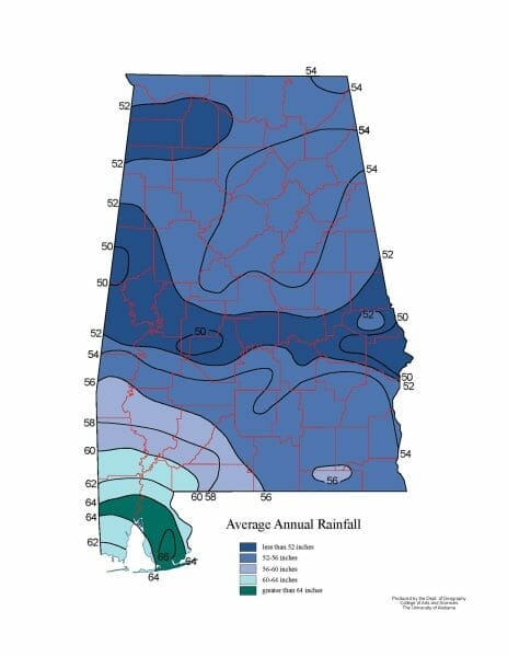
Precipitation
 Average Rainfall
Precipitation patterns tend to be higher in the southern half of the state than in the northern half, with the Mobile area averaging up to 65.9 inches and the Huntsville area averaging 57.0 inches. In south Alabama, higher temperatures and precipitation patterns combine to produce a considerable difference in the length of the growing season for agricultural production across the state, which varies from approximately 200 days per year in the north to approximately 250 days per year in the South.
Average Rainfall
Precipitation patterns tend to be higher in the southern half of the state than in the northern half, with the Mobile area averaging up to 65.9 inches and the Huntsville area averaging 57.0 inches. In south Alabama, higher temperatures and precipitation patterns combine to produce a considerable difference in the length of the growing season for agricultural production across the state, which varies from approximately 200 days per year in the north to approximately 250 days per year in the South.
The variation in temperature and precipitation patterns from the north to the south is largely owing to the influence of the Gulf of Mexico, which is possibly the second-most important factor in determining Alabama’s climate patterns. In addition to serving as a source of moisture, this large body of warm water stores energy absorbed from the Sun throughout the year, which helps moderate temperature patterns along the coast. This influence on local temperature patterns is commonly known as the Maritime Effect.
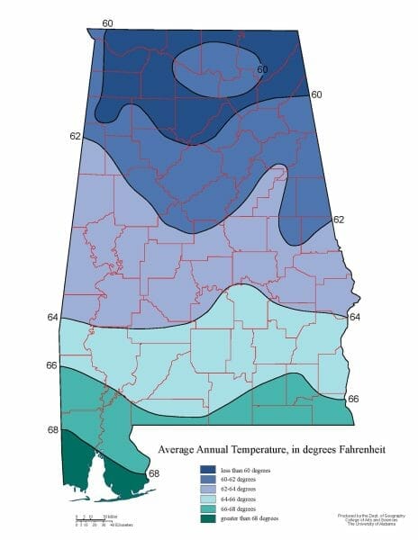 Average Temperature
In summer, a large mass of warm, moist air, known as a maritime tropical air mass, moves northward from the Gulf of Mexico and dominates daily weather patterns in Alabama. In autumn, the polar jet stream begins to migrate southward and directs cool, dry air masses, known as Continental Polar air masses, into the state. The leading edge of the continental polar air mass is referred to as a cold front, and these fronts move across Alabama at a rate of about one per week until spring, when the polar jet stream begins to migrate northward. When a cold front moves across Alabama, the cold, dry air forces the warm, moist air of the Maritime Tropical air mass upward into the atmosphere. The moisture in the warm air soon condenses and returns to the surface as precipitation. As the cold front passes overhead, the cold, dry air mass moves into the region and dominates daily weather patterns for several days. Cold, sunny weather usually prevails until the next cold front moves into the region. The precipitation that normally occurs when the cold front passes is usually in the form of intense rainfall; however, it occasionally occurs as snowfall. Snowfall is more common in the northern region of the state than in the south, but snow is still a relatively rare phenomenon in Alabama. The highest recorded amount of snowfall during a 24-hour period appears to be 13 inches on March 12-13, 1993, at Birmingham.
Average Temperature
In summer, a large mass of warm, moist air, known as a maritime tropical air mass, moves northward from the Gulf of Mexico and dominates daily weather patterns in Alabama. In autumn, the polar jet stream begins to migrate southward and directs cool, dry air masses, known as Continental Polar air masses, into the state. The leading edge of the continental polar air mass is referred to as a cold front, and these fronts move across Alabama at a rate of about one per week until spring, when the polar jet stream begins to migrate northward. When a cold front moves across Alabama, the cold, dry air forces the warm, moist air of the Maritime Tropical air mass upward into the atmosphere. The moisture in the warm air soon condenses and returns to the surface as precipitation. As the cold front passes overhead, the cold, dry air mass moves into the region and dominates daily weather patterns for several days. Cold, sunny weather usually prevails until the next cold front moves into the region. The precipitation that normally occurs when the cold front passes is usually in the form of intense rainfall; however, it occasionally occurs as snowfall. Snowfall is more common in the northern region of the state than in the south, but snow is still a relatively rare phenomenon in Alabama. The highest recorded amount of snowfall during a 24-hour period appears to be 13 inches on March 12-13, 1993, at Birmingham.
Weather Hazards
 Enterprise Tornado
Tornadoes are one of the deadliest weather hazards in Alabama. They are commonly associated with the passage of cold fronts because the interaction of the cold, dry air mass and the warm, moist air mass produces an area of unstable weather conditions along the cold front that are ideal for tornado formation. This area of unstable atmospheric conditions is known as the Squall Line. Alabama averages approximately 20 tornadoes per year. The most common months for tornado formation in the state are March, April, and November, but they occur throughout the year. Alabama is unusual in that it has both a spring and an autumn tornado season. Tornadoes can occur at any time of the day, but they are most common between 10 a.m. and 8 p.m., with the peak time at approximately 5 p.m. The two most common areas for tornado activity in Alabama are the north-central region around Birmingham and the southwest region around Mobile. Tornado activity in the Mobile area is partially related to hurricanes making landfall along the coast, as hurricanes are commonly known to produce tornadoes as they come ashore.
Enterprise Tornado
Tornadoes are one of the deadliest weather hazards in Alabama. They are commonly associated with the passage of cold fronts because the interaction of the cold, dry air mass and the warm, moist air mass produces an area of unstable weather conditions along the cold front that are ideal for tornado formation. This area of unstable atmospheric conditions is known as the Squall Line. Alabama averages approximately 20 tornadoes per year. The most common months for tornado formation in the state are March, April, and November, but they occur throughout the year. Alabama is unusual in that it has both a spring and an autumn tornado season. Tornadoes can occur at any time of the day, but they are most common between 10 a.m. and 8 p.m., with the peak time at approximately 5 p.m. The two most common areas for tornado activity in Alabama are the north-central region around Birmingham and the southwest region around Mobile. Tornado activity in the Mobile area is partially related to hurricanes making landfall along the coast, as hurricanes are commonly known to produce tornadoes as they come ashore.
The worst overall tornado disaster in the state was the Dixie Tornado Outbreak of April 27, 2011. The event, according to preliminary data, produced 268 tornadoes throughout the United States on a single day and set the record for most lives claimed in a single day, at 314. More than 50 tornadoes were reported in north and central Alabama, claiming 238 lives. The highest number of deaths occurred in Tuscaloosa County (39), DeKalb County (33), and Franklin County (27). Initial surveys indicate that eight of these tornadoes were rated EF4 and two were rated EF5 on the Enhanced Fujita Scale (a 2007 updated version of the classic Fujita Scale of tornado intensity). Two of the worst individual tornado disasters in the state occurred on the same day as part of the famous Super Tornado Outbreak of April 3 and 4, 1974, which produced 148 tornadoes and affected 13 states across the South and Midwest. On the evening of April 3, two F5 tornadoes on the Fujita Scale hit Tanner approximately 30 minutes apart and left 55 dead. Later that same evening, another F5 tornado hit Guin and left 23 dead. Other notable tornado disasters in Alabama include the Birmingham tornado of April 15, 1956 (25 deaths); the Huntsville tornado of November 15, 1989 (21 deaths); the Palm Sunday tornado that destroyed the Goshen United Methodist Church in Cherokee County on March 27, 1994 (20 deaths); and the Oak Grove tornado of April 8, 1998, (32 deaths).
Hurricanes are arguably the most important weather hazard in the state in terms of economic damage. Hurricanes are members of a category of meteorological events known as tropical cyclones. More specifically, a tropical cyclone with a sustained wind speed of 39–73 mph is classified as a “tropical storm” and a tropical cyclone with a sustained wind speed of 74 mph or greater is classified as a “hurricane.” The tropical cyclone season in Alabama extends from May to October, with September being the peak month. Tropical cyclones hit Alabama at an average rate of approximately once every 1.5 years. Hurricanes (i.e., storms with sustained wind speeds of 74 mph or greater) hit Alabama approximately once every 7.5 years. Fortunately, most of the tropical cyclones (tropical storms and hurricanes) that hit Alabama actually make landfall in another state, which helps reduce the amount of damage reported in the state. The average rate at which hurricanes actually make landfall along the Alabama coast is relatively low, at approximately once every 16 years. When hurricanes hit the Alabama coast, the amount of damage they cause is usually catastrophic.
 Hurricane Ivan
Two of the most infamous hurricanes to make landfall along the Alabama coast were Frederic in 1979 and Ivan in 2004. Hurricane Frederic was a category 4 on the Saffir-Simpson scale when it crossed Dauphin Island on the evening of September 12, 1979. The official wind speed at the time of landfall was estimated to be 132 mph, but an unofficial wind speed of approximately 145 mph was reported on the bridge that crosses over to the island. The total cost of the damage in Alabama was estimated at $1.4 billion. Hurricane Ivan was a category 3 on the Saffir-Simpson scale when it made landfall at Gulf Shores, Baldwin County, on the evening of September 15, 2004. The official wind speed at landfall was estimated to be approximately 120 mph. The total cost of the damage in Alabama was estimated at $3 billion.
Hurricane Ivan
Two of the most infamous hurricanes to make landfall along the Alabama coast were Frederic in 1979 and Ivan in 2004. Hurricane Frederic was a category 4 on the Saffir-Simpson scale when it crossed Dauphin Island on the evening of September 12, 1979. The official wind speed at the time of landfall was estimated to be 132 mph, but an unofficial wind speed of approximately 145 mph was reported on the bridge that crosses over to the island. The total cost of the damage in Alabama was estimated at $1.4 billion. Hurricane Ivan was a category 3 on the Saffir-Simpson scale when it made landfall at Gulf Shores, Baldwin County, on the evening of September 15, 2004. The official wind speed at landfall was estimated to be approximately 120 mph. The total cost of the damage in Alabama was estimated at $3 billion.
Alabama’s relatively mild climate is a major factor in two of the state’s most important economic activities: agriculture and tourism. For example, the Gulf Coast is an attractive destination during the winter months for vacationers fleeing harsh conditions in the northern United States. The pleasant experience of a warm, mild winter convinces many of these people to make Alabama their permanent home upon retirement.
Further Reading
- Carter, E. A., and V. G. Seaquist. Extreme Weather History and Climate Atlas for Alabama. Huntsville, Ala.: Strode, 1984.
- Evans, C. M. The Complete Guide to Alabama Weather. Birmingham, Ala.: Seacoast Publishing, 1999.